David Dreverman steps down as Director, eWater Limited Board
David Dreverman steps down as Director, eWater Limited Board, after 15 years of service and support to eWater Group.
eWater Limited Board Independent Director David Dreverman announced today at the Annual General Meeting his decision to step down after 15 years of service and support to eWater and its goals.
eWater Group and the eWater Limited Board commended David for his sound advice and support – from eWater’s early beginnings as a Cooperative Research Centre to the Australian and world-leading organisation that it is today.
David brought more than 40 years of experience and understanding of the water sector in Australia and internationally to the eWater Limited Board and the wider organisation, including an Executive Director of River Management at the Murray-Darling Basin Authority, and the Murray Darling Basin Commission.
Prior to these roles, David worked as a consultant in the engineering industry; with SMEC, Hydro Electric Commission, Tasmania and Australian Power and Water.
Michael Wilson, Group CEO, eWater Group, said, “David’s contribution to ensuring better and more sustainable and equitable water management outcomes in Australia – and his contribution to eWater in particular – has been extraordinary.
“It has been a privilege to have had the benefit of David’s wisdom and counsel for so long, and the legacy he leaves to eWater Group’s Australian and international work is immeasurable.
“We thank David for his energy, diligence, and all-embracing passion for water management across the globe.”
Greg Claydon PSM, Chair, eWater Limited Board, said, “I wish to acknowledge David’s wonderful contribution to eWater, and indeed water resource management in Australia and internationally, over many years. I thank him very much for his wise counsel, deep knowledge, and very helpful insights, always aimed at achieving better outcomes.”
Who are we?
eWater Group is owned by the Australian Federal, State and Territory governments to further develop Australia’s world-class modelling tools and to provide support and training nationwide and internationally.
Our organisation is comprised of three divisions – eWater Solutions, the Australian Water Partnership and the Mekong Water Solutions to deliver water management solutions for communities in Australia and overseas.
We also partner with the Australian Department of Foreign Affairs and Trade, and research groups and institutions to provide expertise and support for sustainable water management solutions in Australia and internationally, now and into the future.
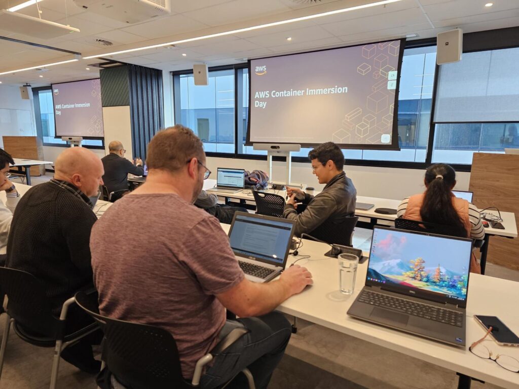
Training for software development team
AWS Immersion Day on Containers
Our software development team attended an Amazon Web Services Immersion Day on Containers, part of our ongoing focus to ensure that modernized versions of eWater’s Source software continue to best support Australian Governments as they continue to evolve their hydrological modelling capabilities.
We’re not talking Storage World or Marie Kondo; these Containers are packages of software containing all of the necessary elements to run in any environment. In this way, containers virtualise the operating system and run anywhere, from a private data center to the public cloud or even on a developer’s personal laptop.
Containerisation is a powerful way to ensure seamless application operation and availability during updates, load spikes, and partial error conditions. Running containers in the cloud allows companies to build robust, scalable applications and services.
This training will help our amazing team of developers to support new projects and new ways of leveraging the power of eWater’s Source hydrological modelling tool.
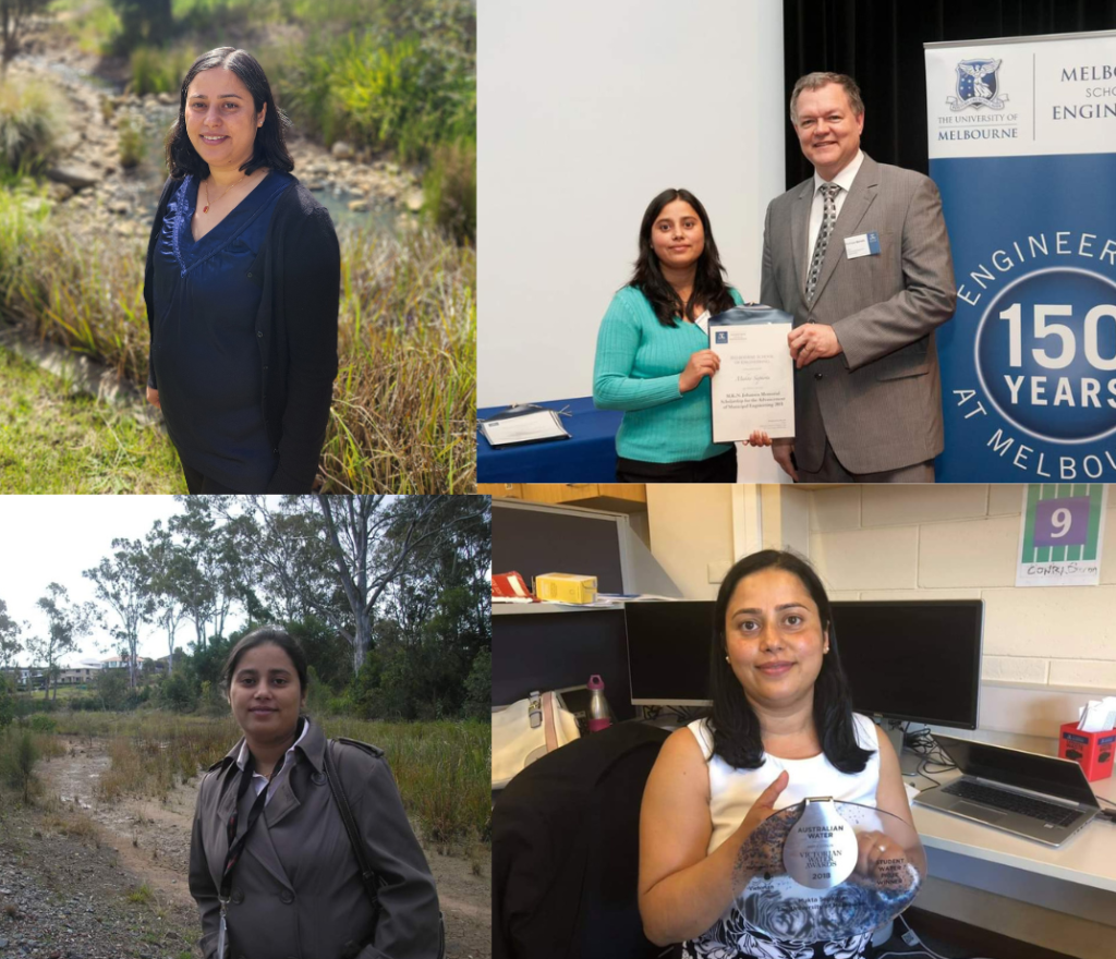
Meet our people – Juanita Moolman
Our hydrologists are exceptional people with diverse skillsets and experience from Australia and around the world. At eWater Group we are lucky to have a team of hydrologists providing their expertise and knowledge.
We can’t tell the story of eWater Group without our people; they are what makes our organisation what it is.
Our team are the backbone, and we want to celebrate and recognise them by putting a spotlight on one of our most respected and senior hydrologists, Juanita Moolman, who has been at eWater Limited since 2012.
Tell us about yourself?
How our world works and the people who live on it has always spurred a deep curiosity for Juanita who has had a long-distinguished 35-year career in both South Africa and Australia. Her love for the natural world was reinforced while at university where she spent her summer holidays collecting field data to be input in the modelling system being developed in the local Hydrology Department and grew from there, culminating her obtaining Honours in Hydrology.
Her career in South Africa saw her working with new hydrological technology and research, at the time, and to be applied it to local dams, irrigation, and catchment areas across South Africa, before taking this experience and moving to Australia 13 years ago for new opportunities, including the Bureau of Metrology, before joining eWater Group.
What is your role at eWater Group?
As an integrated water resource scientist at eWater Group, she contributes skills in catchment hydrology, spatial analysis, and automated big data analysis.
“As a hydrologist at eWater, I am in the business of contributing to the creation and use of the tools to effectively manage our increasingly threatened water resources, which can help meet the United Nations Sustainable Development Goal (6) ensuring availability and sustainable management of water and sanitation for all.”
What project are you most proud of?
Juanita has worked on many projects during her 13 years at eWater that she has felt honoured to be a part of, including her role in the first-ever integrated assessment of the Ayeyarwady River Basin in Myanmar in 2017. The Basin, which starts in the Himalayas and runs through Central Myanmar, is a major water resource for the communities that live alongside it.
The project, supported by the World Bank and Australian Water Partnership, saw eWater Group develop a Source water system model for the Basin to understand water availability and uses, as well as implications for climate change.
“It felt honored to be part of a group of people brought together from various global organisations to document the understanding of the Basin for the first time. And providing something which can be used as a baseline for future work.”
What does it mean to work at eWater Group?
She has a strong interest in building the capacity of future generations to meet the challenges that will be facing global water availability. “As part of my role I have had the opportunity to train and mentor hydrologists from across the region as well as our own team and sharing my knowledge and experience with them is very rewarding for me.”
For Juanita, working at eWater Group provides the opportunity to be at the forefront of the conversation when it comes to water management and modelling in this country. “As the custodian of Source, the national hydrological modelling platform, we have the tool that is designed to manage Australia’s water resources. It is a key tool to understanding our changing environment, water quality and management, and how we respond to it.”
Water – either its presence or lack of – remains an important issue in Australia and internationally. For eWater, our hydrologists, together with our software developers and our broader teams, can provide our governments and partners the expertise, knowledge, and tools to make informed and sustainable decisions for our future.
Want to find out more?
For more information about eWater Group Source and its other world-class tools – Tools – eWater
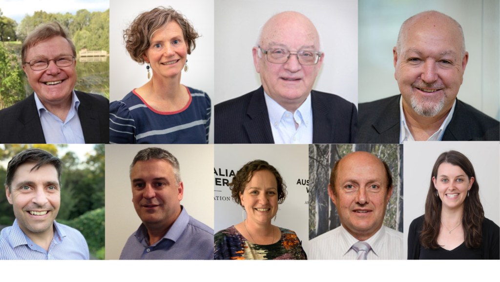
eWater Limited Board elects new chair and board members
Our recent Annual General Meeting marked a great opportunity for our Board and people to come together to share and celebrate our achievements in 2022.
This year, we farewelled our former chairman, Don Blackmore AM, who was chair since the formation of eWater in 2005. Don made an incredible contribution to Australian water management through various roles including Chief Executive of the Murray-Darling Basin Commission, and Deputy Chair of Land and Water Australia.
The AGM also marked new beginnings with the election of a new chair, Greg Claydon PSM, and two new Independent Directors, Kathryn Silvester, and Dr Grace Mitchell. They join our ongoing Directors – Murray Rankin, Bob McMullan, David Dreverman, Deb Brown, Mitchell Isaacs, and Andrew Reynolds on an expanded Board.
Each of our Directors brings a diverse range of skills and experience to our organisation including water policy and management, commercialisation of Australian technology, international development, research and development, public policy, governance, and strategic planning.
Greg Claydon, Chair, and Independent Director
Greg has extensive experience within the water industry as well as natural resources management, both in Australia and internationally. He has been recognised at state, national, and international levels for his work in water and associated national resources reforms, in whole of river basins planning and management, and in integrated urban water management. Greg has held many board memberships including the Murray-Darling Basin Commission, CRC for Water Sensitive Cities, International Water Centre, COAG Water Reform Committee.
Dr Grace Mitchell, New Independent Director
Grace brings a wealth of knowledge to the eWater Limited Board including leading numerous high-profile, complex, multi-disciplinary initiatives that have required significant stakeholder engagement and negotiation within and between state and federal governments. With a PhD in Environmental Engineering from Monash University, Dr Mitchell has a proven track record in delivering complex policy initiatives and program outcomes, which will benefit the eWater Limited Board and eWater’s government owners, customers, stakeholders, and clients.
Kathryn Silvester, New Independent Director
Kathryn brings extensive knowledge and experience to the eWater Board including her work at the Sydney Water Corporation as Resilience and Climate Changer Adaptation Manager. Kathryn is a passionate water professional and has been a member of the International Water Association and Australia Water Association strategic councils, providing advice to their Boards of Directors.
Murray Rankin, Re-elected Independent Director
Murray is a director and chair of numerous boards of innovative Australian companies as well as serve on several government boards as a technology adviser. He has won numerous national business awards including the Telstra Small Business of The Year. He is an occasional lecturer in business strategy at the Australian National University, Macquarie University and Melbourne Business School.
David Dreverman, Independent Director
David has held many distinguished roles over his extensive career, including Executive Director, River Management, Murray-Darling Basin Authority, and General Manager, River Murray Water of the Murray-Darling Basin Commission. He has also worked as a consultant in the engineering industry; with SMEC, Hydro Electric Commission Tasmania and Australian Power and Water. David has been involved with large dam and hydropower projects, both in Australia and overseas for more than forty years.
Bob McMullan, Independent Director
Bob has held several ministerial positions in the federal government over his career, including Minister for the Arts, Minister for Trade, and Parliamentary Secretary for International Development Assistance. He represented the Australian Capital Territory in both the Senate and House of Representatives.
Since leaving parliament, Bob has been involved in a range of activities, with a focus on international development, including Director of the ANU Crawford Leadership Forum, Board Member for the Crawford Fund and Foundation for Development Cooperation and as Australian Executive/Alternate Director for the European Bank for Reconstruction and Development.
Mitchell Isaacs, Owner-nominated Director
Mitchell Isaacs has worked in water related roles in the NSW Government since 2009 and from November 2020 as the Chief Knowledge Officer, Water Group, in the NSW Department of Planning, Industry and Environment. Prior to joining the NSW Government, Mitchell worked as a research scientist in Australia and Japan, and as a project management advisor to the Cambodian Government’s Fisheries Administration.
Deb Brown, Owner-nominated Director
Deb Brown is the Executive Director, Catchment Waterways Cities and Towns in the Water and Catchments Group of the Victorian Department of Environment, Land, Water and Planning, and a trusted and respected water leader with over 20 years’ experience within the public sector. Over her career, Deb has specialised in urban water management and conservation, environment, and river health improvement, and more recently in improving Traditional Owner inclusion in water management.
Andrew Reynolds, Owner-nominated Director
Andrew Reynolds has more than 24 years’ experience in the water industry, managing major water supply infrastructure, as well as extensive knowledge in the fields of engineering project management, dam safety and construction management. Andrew is the Executive Director, River Management at the Murray-Darling Basin Authority. Prior to that role, Andrew held various roles with Goulburn-Murray Water which included management of the Headworks business responsible for 16 large dams and associated infrastructure, delivery of several major dam safety upgrade projects, and leading the business’ engineering and scientific resources.
eWater Group and its people are happy to welcome new and continuing members of the eWater Limited Board to vital strategic conversations about Australia’s and the globe’s water future.
Meet Our People at eWater – Mukta Sapkota, Urban Hydrologist
Why is urban hydrology so important? Why do we need to care? And what does an urban hydrologist do exactly? All good questions to a complex and vital industry, particularly in Australia and its diverse weather and climate.
At the eWater Group, we have a broad skillset. We are made up of hydrologists, software developers, water industry experts and innovators. We are diverse, experienced, and most importantly we have a strong heritage of supporting sustainable water management.
Mukta Sapkotais one of our resident Urban Hydrologists, who has been working at the eWater Group for nearly four years, together with more than 10 years’ experience in urban water systems and hydrology in Australia and overseas.
At eWater…
Mukta provides specialist technical support to eWater Source, MUSIC, and Urban Developer software users.
“As part of my role, I provide specialist technical support to eWater software users and assist in the delivery of various water projects and training courses. I also test and document the specification of the new and existing functionality of eWater software, and am involved in the development of business development proposals and participate in project applications.”
For Mukta, not one day is the same. “One minute I am providing modelling support to a client, the next moment, I am into software hydro-testing, then documentation. I am very passionate about sustainable water management and thrilled to work at eWater that subscribes to the same vision. I always enjoy helping people learn and solve their problems.”
“My role at eWater provides a great opportunity to challenge myself and test my skills. I love the variety and wonderful things I am learning each day by supporting clients. I equally enjoy delivering training.”
Sustainable water management approach
Countries around the world, including Australia, are facing increased pressure on water resources from growing populations, social and economic ambitions, increasing industrialization, demanding agriculture, and environmental flow needs. In addition to this, changing climate and an increase in the frequency of extreme weather events have added extra pressure.
For Mukta, an integrated water planning approach that considers demand management, wastewater/ stormwater recycling/reuse, and water trade/transfer, is required to support resilience to climate change, the wider pressures of various demands, and environmental protection. Such a development of sustainable water management needs holistic modelling tools.
“eWater’s Source, integrated with Urban Developer and MUSICX, offers an integrated modelling platform to support water managers in modelling such complex water management problems and help in decision-making for sustainable water management.”
Supporting Women and Girls
The future of water resources and sustainability isn’t the only issue Mukta is passionate about – supporting women and girls in hydrology.
A sustainable workforce requires diversity. Giving women and girls opportunities to consider hydrology, or other STEM roles, starts with education and creating opportunities to go into these fields as adults, as well as breaking down the barriers for current female hydrologists in the industry.
“I believe we need more women and girls in hydrology to maintain gender diversity for creating a healthy work environment at workplaces. We also need more women in higher management to foster gender equality and put forth women in leadership to ensure this principle is implemented.”
Mukta is just one great example of women, in both Australia and internationally, being supported to pursue and thrive in STEM careers, and eWater is excited to have her as part of our team.
MUSICX v1.10 Released
MUSICX, the industry-leading stormwater modelling tool, has been completely re-designed and rewritten while maintaining all the capabilities of classic MUSIC.
MUSICX is the most significant upgrade of MUSIC in a decade. The users will see many additional benefits in our upcoming production release (v1.10) including a powerful and flexible tabular data editor.
New features in MUSICX v1.10:
• Tabular model data editor
• Text/Excel export and import features for nodes
• Muskingum Link storage routing
• Summary Report Generation capability (like MUSIC v6.3)
• Background image supported
• Improvement in Results Manager
• Editable Advance Model parameters
• Additional functionalities
Our live demonstration will offer an opportunity to see firsthand how this vital tool is helping to inform the development of water quality and quantity standards in our towns and cities across Australia and overseas.
MUSICX is a critical tool that enables urban developers, planners, and engineers to manage the impact of urban development and other land use changes on waterways.
Damien Pearson has joined eWater in the recently created role of General Manager. Reporting to the eWater Limited Group CEO, Michael Wilson, Damien will be responsible for the day-to-day management of eWater’s software development and hydrological modelling services and contribute to the strategic direction of the eWater Limited Group.
Improving Livelihoods in Northern Cambodia
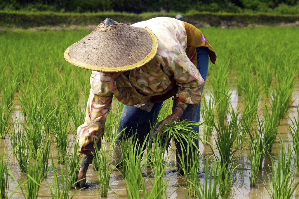
More than 300,000 people living in Stung Staung river basin in Northern Cambodia rely on agriculture for their livelihoods. Access to a clean water supply is fundamental for wellbeing and health particularly to prevent transmission of the COVID-19 virus. Increased food security, higher income for farmers and improved health in the villages can be expected if the reliability and quality of water supplies in the province can be enhanced through improved sharing of existing water supplies.
Partnering with the World Bank and support from the Royal Government of Cambodia (RGC), eWater undertook a study to assess the challenges of water supply development and to establish an enabling environment, based on scientific evidence, for a water sharing dialogue between authorities, farmers and relevant water users and assist with developing a long-term investment plan for water supply utility for Staung district in Kompong Thom Province.
(AdobeStock, Rice worker planting rice in a rice field, by Michel)
Study Area
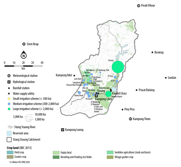
The Stung Staung river rises in the mountains of Northern Cambodia before flowing 213 km to the iconic Lake Tonle Sap, one of the largest freshwater lakes in the world. In its northern reaches, the river flows through forest before entering expansive cropland to the south. The majority of the 217 villages in the catchment are along the river in the farming districts which cover about a third of the catchment. More than a quarter of the people in the river basin live in poverty.
Competition between irrigation and village water supplies is increasing as climate change varies the annual rainfall pattern. Barrage ‘Samsep Kagna’ of 7,200 ha is the only large irrigation scheme in the catchment. Other existing schemes include 17 medium schemes and 8 small schemes (Figure 1). Currently, rainfed paddy rice is the main crop in the command areas, but further downstream field and garden crops are more common.
Figure 1: Irrigation schemes and water supply utility in the Stung Staung Catchment.
To help manage the water competition and cope with climate change, a large water reservoir of the Staung Water Resource Development Project with a potential area of 30,000 ha is planned.
Clean water supply in the coverage areas comes from the Stung Staung River, supplemented with groundwater from a 200m deep tube well next to the treatment plant near the river. A World Bank’s Water Supply and Sanitation Improvement Project (WaSSIP) aims to increase water supplies to villages by up to four times through a new water supply utility near Barrage ‘Samsep Kagna’.
Development of a Source model to assess demand and supply
Through 2019-2020, funded by the World Bank, eWater, in collaboration with the Institute of Technology Cambodia (ITC) and Ministry of Water Resources and Meteorology (MOWRAM), and Ministry of Industry, Science, Technology and Innovation (MISTI) undertook a comprehensive catchment assessment in the Stung Staung River and developed a Source model to support dialogue on a water sharing plan in the catchment. The outcome of the assessment will support the design of future water supply infrastructure and investment potential of the RGC and the World Bank in Staung district.
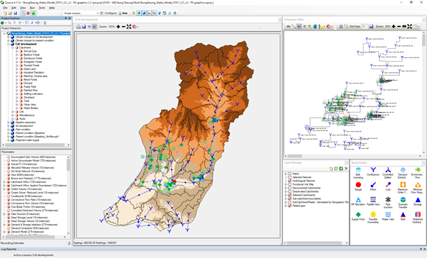
Stung Staung River Source Model
Methodology
The data review included demography, geography, water sources, status and trends of water supply and demand, initial potential risks and mitigation measures. Additional hydrometeorological datasets were collected to help refine the existing country-wide Source model to form the Source Stung Staung Model, the model supports hydrological and water system modelling. The hydrological model was used to undertake a water balance assessment that characterised the natural condition (rainfall-runoff process) in the catchment. The water system model was run to quantify water demand from various sectors, mainly irrigation activities and municipal water requirements.
Once the hydrological characteristics for the catchment were defined, several future scenarios were formulated and later assessed using well calibrated models of the pre-development and future-development scenarios. This allowed for an assessment of potential hydrological risks. The simulations quantified surface water availability from the natural processes of rainfall-runoff and water resource use by different sectors. Hydrological baseline statistics were developed, which characterised the water supply/demand balance on a monthly, seasonal and annual basis.
Climate change impacts
An analysis of rainfall patterns over the Stung Staung Catchment reveals an observed change in rainfall between the past condition (2000-2011) and the present condition (2012-2019). The pattern of mono-modal with a peak in September has changed to bi-modal with peaks in July and September. A decrease in rainfall in August was clearly observed for all the key stations. Particularly, a big change in rainfall was observed at Stoung in the lower section of the river. Monthly rainfall in the wet season dropped about 100 mm. A significant drop was in September: decreasing from about 400 mm to below 200 mm. The climate change assessments suggest a decrease in all flow ranges from the present condition.
Pathway to resilient water resources
The project allows the Cambodian authorities to consider the developed workflow and application of the Source Modelling Platform for water balance analysis and catchment assessment as a scientific tool to support water allocation mechanisms.
The study recommended, through community discussions, establishing a minimum requirement for water quantity and quality as the priority for domestic water supply. Understanding community priorities will assist the large water storage managers in developing an equitable water sharing plan for domestic and irrigation water. While there is a potential for expansion of irrigation scale, the irrigation modernisation should be taken into account of water balance to improve the sustainability of the irrigation system, providing benefits to farmers and the downstream biodiversity and aquatic environment in the river. Crop intensification would lead to higher irrigation water demand resulting in water shortage so shifting the crop growing calendar could be considered as a way to ease water shortages in May and June.
With signs of less water available in the future, the villages in the river basin need to discuss their options, such as crop diversification to high value crops, which may generate greater income with less water. The study provides valuable details and guidance for the authorities and villagers in the river basin to mitigate risks and for Development Partners to investigate water resource development option and enhance water resource management benefits in the Stung Staung Basin.
The eWater team has been working hard on a number of updates to MUSICX, with a new version out now, highlights include: – MUSIC-link – The ability to add notes to individual nodes – Additional recorders, including Overflow, Pipe flow, Water Level, Storage, Water Demand and Reuse – allowing a Monthly Pattern as Data Source for PET
In a special ceremony in Phnom Penh, Australia’s Ambassador to Cambodia, His Excellency Pablo Kang formally gifted access to Australia’s national water modelling platform, eWater Source to Cambodia’s Minister of Water Resources and Meteorology (MOWRAM) His Excellency Lim Kean Hor.
This technical exchange forms part of Australia’s ongoing support for sustainable water management throughout the Mekong region.
eWater Source, Australia’s national hydrological modelling platform will assist the Cambodian Government to better understand the availability of water resources throughout the country. It will provide a stronger evidence base on which to make decisions about the development of water infrastructure and the allocation of water for a range of users – cities and towns, farming and freshwater fisheries, hydropower and industry.
“The sustainable management of Cambodia’s precious water resources is crucial to support the socio-economic development of our cities and of our growing agriculture and energy sectors, while preserving our unique environment” stated His Excellency Lim Kean Hor.
“We welcome the offer by the Government of Australia to provide both technical tools and capacity building support so that Cambodians can learn from the Australian experience and improve our management of water resources for the entire country.”
In response, Ambassador Kang said “We are pleased to share an important Australian innovation – the eWater Source platform –with our neighbours and friends in Cambodia, because doing so will help ensure water governance is based on solid evidence and can contribute to Cambodia’s post-COVID recovery”
eWater has worked with the Mekong River Commission (MRC) its member countries (Cambodia, Laos, Thailand and Vietnam) for many years. Starting in 2013, eWater developed a Source model of the entire Mekong River and major tributaries, ultimately leading to eWater contributing to the 2018-19 MRC Council Study using Source to integrate information and existing basin models.
In 2017-19, eWater, in partnership with UNESCAP, Geoscience Australia and the Australian Bureau of Meteorology implemented a pilot in Cambodia using space-based data to help water users in drought prone countries to better understand and manage droughts. eWater provided updated technology and access to satellite data through the Geoscience Australia Open Data Cube to improve the ESCAP Regional Drought Mechanism. In 2019 eWater was appointed as an adviser to MOWRAM in Cambodia under a World Bank project.
Source 5.0 Highlights
Released in June 2020, Source 5.0 contains many new features and enhancements, including the new Urban Developer plugin.
Understanding the water resources of the Ayeyarwady Basin, Myanmar
The Ayeyarwady River is Myanmar’s largest and most commercially important river but its water resources are not well understood.
With the support of the Australian Water Partnership, the Government of the Republic of the Union of Myanmar commissioned the first integrated assessment of the natural resources of the Ayeyarwady Basin. eWater lead the surface water assessment for the State of the Basin Assessment (SOBA).
The Ayeyarwady Basin
With an area of just over 675 000 km2, the Republic of the Union of Myanmar is the second largest country in South-East Asia, after Indonesia.
The Ayeyarwady River starts in the Himalayas, flowing for approximately 2 000 km in a north-south direction through Central Myanmar. The river basin has a total area of 413,700 km2 and covers about 61% of Myanmar. About 5% of the Basin extends into the neighbouring countries of India (to the west) and China (to the east).
The Ayeyarwady River Basin is dominated by a monsoonal rainfall regime, associated with the south-western Indian monsoon. It is also affected by convectional systems and cyclones from the Bay of Bengal. Groundwater flows to the streams and snowmelt from the northern regions are also important contributions to basin flows.
The Ayeyarwady River Basin is still a relatively undeveloped basin. Like the majority of Myanmar, most of the Basin is characterized as rural, with agriculture the main use of water.
Ayeyarwady River, view from Bupaya bagan (credit: tuanjai62/ Adobe Stock)
Project overview
The SOBA provides a baseline assessment of the basin’s water and other natural resources, from which future management options can be compared against.
eWater developed a preliminary baseline Source water system model for the Ayeyarwady Basin (north of the delta), from which a baseline assessment of the basin’s surface water resources was undertaken.
The model is run with historic climate data for 1982 to 2016, land use in 2014 and storage capacity in 2016. It represents agriculture, domestic, urban and hydropower water use.
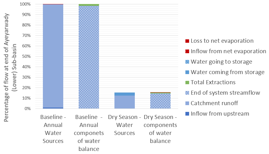
For the first time, the baseline assessment gives water managers a description of the hydrology of the Ayeyarwady River Basin according to 5 Hydro-Ecological Zones and 13 sub-basins, significantly increasing the understanding of both water availability and water use in the basin. For example, in the figure below, we can see the different components that contribute to flow at the end of the system as an annual total and during the critical dry season, it shows how much water is provided by different sources and how much of this water is used or lost to evaporation.
Flow components at the end of the Ayeyarwady Basin, annually and in the dry season
The water system model is a first cut at drawing together the information required to adequately understand and simulate the complexities of the Ayeyarwady River Basin. The baseline model will be a key tool to support the future management of the basin’s water resources, making it possible to:
Combine outputs from the model together with observed values, to provide an overall assessment of water availability and uses across the Ayeyarwady River Basin.
Understand baseline water availability and use, to support the ongoing assessment of the Basin’s water resources and to examine possible future scenarios and possible implications, for example with climate change or increased agricultural use.
Simulate components of the hydrological cycle at locations where observed values are not available.
Identify information gaps and inform future data collection initiatives.
Scoping Study
Following the completion of the SOBA, eWater was engaged to undertake a scoping study of potential development options for the mainstream of the Ayeyarwady River and tributary flows. The study was also supported by the Australian Water Partnership.
The scoping study sought to demonstrate how water resource models can be used to assess management scenarios and provide valuable outputs to support stakeholder consultation.
The surface water system model was adapted to allow it to provide information on the likely changes in the Ayeyarwady mainstream and tributaries from different development scenarios. The scoping model can assess the likely flow changes from different development options, to consider the impact on water dependent outcomes such as irrigation, hydropower production, surface water flow heights and and flood magnitude. It is not intended to evaluate specific development proposals.
The scoping model was used to compare a High Development Scenario of hydropower on the tributaries and some irrigation development in the Central Dry Zone against a baseline scenario. The baseline scenario included ‘current’ irrigation demand and hydropower dams representing 2000 megawatts of hydropower, it does not include some 30 irrigation storages where data was not available.
The results compared include:
Change in hydropower generation on an annual and seasonal basis, inter-annual variability was also assessed.
Agriculture water use and availability assessed on an annual and inter-annual basis.
An assessment of changes to hydrographs at Sagaing, Pyay and Monywa, including changes in flow volume as well as surface water level.
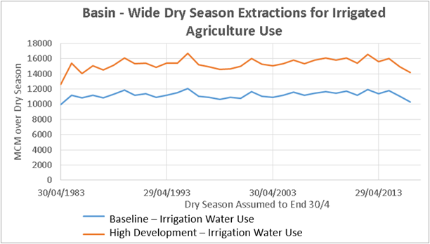
An example of the scoping model outputs is shown below. In this, dry season irrigation extraction under the baseline and high development scenarios are compared.
Dry season demand for water under the baseline and high development scenarios.
Capacity Building
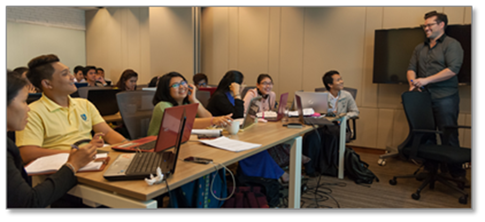
eWater conducted face to face training programs to introduce water managers in Myanmar to the principles of hydrological modelling and the use of Source. The training used the new Ayeyarwady Source model, providing participants with hands-on experience in the use of the model.
eWater’s Geoff Davis presenting Source training in Myanmar
A new home for ICE WaRM
In July 2020, ICE WaRM, the International Centre for Excellence in Water Resource Management, entered into a collaboration with eWater Ltd to re-launch its international water education and training program.
The collaboration will build on the established strengths of both organisations. ICE WaRM’s substantial experience in designing and delivering education, training and capacity building programs will be enhanced by eWater’s practical training in water modelling tools and capacity building to connect modelling with policy, regulation and management.
The new program will be strengthened by the range of ICEWaRM education and training programs that draw on South Australia’s’ water technology and expertise.
Arranginginternational study visits will step up a level through the combined practical experience and detailed knowledge of the Australian water sector of ICEWARM and eWater.
ICEWaRM’s strong commitment to inclusiveness across its programs will complement eWater’s efforts, in gender equity and social inclusion.
Designing a Stormwater System for an Urban Biodiversity Corridor
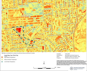
The drainage reserves that run diagonally through Pasadena from the Adelaide Hills to the Plains are hot, dry and barren.
On an urban heat map (right), the reserves show up as the hottest areas in the locality, scarring the otherwise leafy suburb. Due to open unirrigated bare ground, the reserves contribute more urban heat island impacts than surrounding roads and structures.
The site is near a popular shopping centre, important recreation areas and in an area destined for further urban infill. A radically different passive recreation space is needed to serve the community both now and into the future, and climate change makes quality open spaces rarer.
Revitalising Reserves with a Biodiversity Corridor
Water Technology completed a conceptual design of a multi-function stormwater system for a new Biodiversity Corridor. The stormwater system diverts runoff into a number of underutilised reserves within the City of Mitcham in the Adelaide foothills.
The project revitalises the reserves by providing much-needed water for irrigation and new native tree plantings. This is achieved by daylighting urban stormwater runoff from underground pipes into open channels within the reserves and diverting runoff to infiltration trenches for passive irrigation.
In this way, stormwater management will help deliver multiple benefits, including improving public health, local biodiversity, and providing a green and open space for the local community to reconnect.
eWater MUSIC was a key Water Sensitive Urban Design conceptual design tool used for the project. eWater MUSIC allowed engineers to model multiple stormwater management functions and evaluate the resulting multiple benefits of the Biodiversity Corridor.
The Biodiversity Corridor concept design completed by Water Technology’s engineering consultants included design input from Outerspace Landscape Architects and was carried out in consultation with the City of Mitcham (below).
The design brings stormwater flows from the underground drainage pipes within the reserves to the surface to create a lush, green, passively irrigated recreation space that establishes a biodiversity corridor linking the Adelaide Hills to the Plains.
Developing green space is a focus, with hundreds of new trees and native vegetation understory plantings all sustained by soakage trenches filled by the above-ground creek flows. Increased moisture availability supports healthier canopies with no supplementary watering even in the longest and hottest dry summer, and most of all, lots of shade to draw people to the space to recreate.
Not only will flora and fauna be drawn to the reserves, but also the community as the reserves will become a focal point for residents to visit, walk, run, explore, and engage with nature through the new trails, nature play water areas, benches and BBQ facilities, Kaurna edible garden, and BMX track.
In an area subject to high urban infill, small lot sizes, and minimal canopy cover, the Pasadena Biodiversity Corridor will become a place that brings the community in and allows them to enjoy a cool, vibrant, passive recreation space among native trees, birds, and animals.
Concept Design Features
The concept design provides for daylighting existing stormwater drains within and near several reserves in Pasadena. The design features extensive new native plantings that will be passively irrigated via daylighted stormwater flows conveyed and filtered through a series of raingardens, infiltration trenches and swales. Detention basins are required to attenuate the daylighted flows to offset a future reduction in pipe capacity proposed at a location downstream of the reserves.
As such, a key design requirement for the Biodiversity Corridor was that the stormwater system needed to perform multiple functions delivering multiple benefits.
The functions and benefits included stormwater harvesting for storage and irrigation of reserves and export off-site, low flow diversions for passive irrigation of new tree plantings, and biofiltration basins, ponds and swales to improve water quality.
In addition, the system must distribute low flows equally to the various reserves to keep the new plantings watered consistently.
eWater MUSIC
Including multiple functions and delivering multiple benefits increased the complexity of the stormwater system for the Biodiversity Corridor. Designing and evaluating the system’s performance was a key challenge.
eWater MUSIC was an essential Water Sensitive Urban Design tool for navigating the complexity of the conceptual design of the Biodiversity Corridor (below).
In particular, eWater MUSIC software was used to:
estimate stormwater runoff volumes from developed areas
estimate and analyse the sensitivity of stormwater harvesting yield
estimate low flow volumes available for diversion as passive irrigation
design biofiltration basins
assess pond storage inundation frequency
estimate water quality improvement required for a stormwater harvesting scheme
estimate the water available for passive irrigation to promote urban cooling.
eWater MUSIC has several unique features that assisted with designing and evaluating Water Sensitive Urban Design approaches in the Biodiversity Corridor. These included:
Secondary links from nodes allowed low flow diversions to be modelled and optimised.
Biofiltration, swale and pond treatment nodes allowed treatment of stormwater to a quality fit for harvesting to be modelled.
Advanced charting within MUSIC allowed rapid assessment of flow frequency at different locations to ensure the system provides equitable distribution of low flows.
Stormwater harvesting demand patterns and custom demands allowed sensitivity analysis and the viability of a harvesting scheme to be assessed.
eWater MUSIC made a complex stormwater model simple to modify and evaluate. Using eWater MUSIC for conceptual design, ensured that the Biodiversity Corridor has the best opportunity to remain robust, sustainable and functional, and will provide multiple ongoing benefits to the local community.
Next Steps
Following construction, the Biodiversity Corridor will become the ‘jewel in the crown’ for the local suburbs, giving the community access to a lush, cool, green space to walk, explore, recreate, and relax.
The upgrade will improve accessibility for the community by connecting the reserves to the adjacent streets, linking footpaths and trails, and providing all-weather walking surfaces, as well as solar bollard lighting for night safety along the path. Rather than dividing the suburb like a peace wall, the reserves will become a location that integrates the community.
The addition of thousands of new native trees and plants will promote the connection of birds and animals from the Hills Face area to the urban plains, expanding their natural environment. By creating the use of passive stormwater as irrigation, it will create a location that is self-sustaining and climate resilient.
Further Information
For further information on the project please contact Water Technology at the details below.
Dr Michael Di Matteo – Water Technology
Dr Michael Di Matteo
michael.dimatteo@watertech.com.au
Phone: (08) 8378 8000
1/98 Greenhill Road, EASTWOOD SA 5063
Ben Taylor
Ben Taylor – Water Technology
ben.taylor@watertech.com.au
National Practice Lead – Urban Water
Phone: (08) 8378 8000
1/98 Greenhill Road, EASTWOOD SA 5063
Paddock to Reef – Integrated Monitoring, Modelling and Reporting Program
Targeting investment to improve the health of the Great Barrier Reef.
What is the Paddock to Reef program?
The Paddock to Reef Integrated Monitoring, Modelling and Reporting Program (Paddock to Reef program) started in 2009 as a joint initiative of the Australian and Queensland governments to report on water quality improvement resulting from investment in improved land management practices. Improving the quality of water leaving properties by reducing pollutant run-off is critical to build the health and resilience of the Great Barrier Reef (GBR). The program brings together industry bodies, government agencies, natural resource management bodies, landholders and research organisations.
The program provides a framework for evaluating and reporting progress towards the Reef 2050 Water Quality Improvement Plan targets. It integrates monitoring and modelling information on management practices, catchment indicators, catchment loads and the health of the Reef at the paddock, sub-catchment, catchment, regional and whole GBR scales (image below). The program evaluates management practice adoption, management practice effectiveness (in terms of water quality benefits and economic outcomes), catchment condition, pollutant run-off and marine condition.
Focus areas for the Paddock to Reef program
How does Source support the program?
The catchment modelling for the program is based on the Source platform, with customised plug-ins developed by the Queensland Government to provide additional water quality functionality. A range of other purpose-built data collection and reporting tools have also been built to support the program. These include interactive maps to show pollutant generation rates and priority investment areas.
The models are primarily used to report on annual progress towards the reef water quality targets as a result of investment in improved land management practices. Model outputs are also used to determine priority areas for investment and to assess possible outcomes from different scenarios such as different rates of adoption of improved practices. The catchment models also provide inputs for the marine models.
The Paddock to the Reef program helps manage the impacts of landuse on the quality of water flowing to the Great Barrier Reef, Qld (credit: WITTE-ART.com / Adobe Stock)
Information sharing
Many of the actions required to achieve the water quality targets need to be undertaken by farmers and other land managers. To support greater uptake of the required actions, the Paddock to Reef program has been designed to share technical information in a way that can be easily understood and used. It also incorporates the local knowledge of land managers. Program features include:
Multiple lines of evidence to inform progress towards the targets.
Technical experts are based in the regions, giving them a good understanding of the local environment, issues and the effectiveness of management actions. This also helps build relationships with local land managers.
Ongoing refinement of the models and other tools to incorporate new knowledge, data and methods.
Results are presented online through an interactive reporting system to cater for the broad range of stakeholders interested in the results from the general public to scientific experts.
Data is made available to support other programs, for example regional report cards and regional natural resource management body and local government investment decisions.
‘Cut down’ models provide locally specific tools to assess individual projects and prioritise local investment.
Peer review, continual improvement and validation are critical elements for any modelling program. The Paddock to Reef catchment modelling program undertakes an external review every three years. The program is supported by a GBR-wide pollutant loads monitoring program which provides data to calibrate and validate the catchment models and increase confidence in the models over time.
This case study was prepared in collaboration with the Queensland Department of Environment and Science.
Asia-Australia Water Learning Week 2019
Sharing Australian water management expertise
Every second year, the Australian water sector hosts the Asian Development Bank (ADB) Asia-Australia Learning Week. The Learning Week is a collaboration between the ADB and the Australian Water Partnership. It brings together team leaders and water specialists from the ADB and ADB project representatives from the bank’s Developing Member Countries (DMC) governments. The focus is for the participants to share knowledge and experience and to learn from Australian water sector specialists and institutions.
The 2019 Learning Week was facilitated by eWater, the International Water Centre (Griffith University) and Alluvium. The week was structured around the theme of the use of decision support tools in water policy development, investment planning and on-ground management of water resources. Nine ADB staff and 17 representatives from DMC governments (from 14 Asia-Pacific countries) participated. The theme was decision support tools to guide water policy development, investment planning and on-ground management of water resources.
The week showcased the use of decision support tools at all scales, from local to catchment and in rural and urban settings. Participants heard from government agencies, water researchers, water utilities and water associations, including:
Murray-Darling Basin Authority
Bureau of Meteorology
Geoscience Australia
CSIRO
the Australian Rivers Institute
University of Queensland
Melbourne Water
Water Services Association of Australia
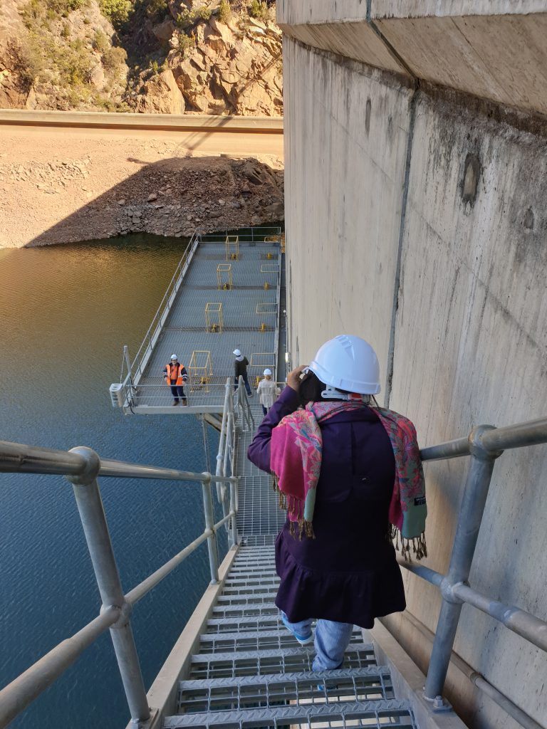
WaterNSW (field trip to Burrinjuck Dam)
Goulburn-Murray Water (field trip to irrigation infrastructure)
Yarra Valley Water (field trip to Waste to Energy plant)