Improving Livelihoods in Northern Cambodia

More than 300,000 people living in Stung Staung river basin in Northern Cambodia rely on agriculture for their livelihoods. Access to a clean water supply is fundamental for wellbeing and health particularly to prevent transmission of the COVID-19 virus. Increased food security, higher income for farmers and improved health in the villages can be expected if the reliability and quality of water supplies in the province can be enhanced through improved sharing of existing water supplies.

Partnering with the World Bank and support from the Royal Government of Cambodia (RGC), eWater undertook a study to assess the challenges of water supply development and to establish an enabling environment, based on scientific evidence, for a water sharing dialogue between authorities, farmers and relevant water users and assist with developing a long-term investment plan for water supply utility for Staung district in Kompong Thom Province.

(AdobeStock, Rice worker planting rice in a rice field, by Michel)

Study Area

The Stung Staung river rises in the mountains of Northern Cambodia before flowing 213 km to the iconic Lake Tonle Sap, one of the largest freshwater lakes in the world. In its northern reaches, the river flows through forest before entering expansive cropland to the south.  The majority of the 217 villages in the catchment are along the river in the farming districts which cover about a third of the catchment.  More than a quarter of the people in the river basin live in poverty.

Competition between irrigation and village water supplies is increasing as climate change varies the annual rainfall pattern. Barrage ‘Samsep Kagna’ of 7,200 ha is the only large irrigation scheme in the catchment. Other existing schemes include 17 medium schemes and 8 small schemes (Figure 1). Currently, rainfed paddy rice is the main crop in the command areas, but further downstream field and garden crops are more common.

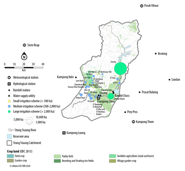
Figure 1: Irrigation schemes and water supply utility in the Stung Staung Catchment.

To help manage the water competition and cope with climate change, a large water reservoir of the Staung Water Resource Development Project with a potential area of 30,000 ha is planned.

Clean water supply in the coverage areas comes from the Stung Staung River, supplemented with groundwater from a 200m deep tube well next to the treatment plant near the river.  A World Bank’s Water Supply and Sanitation Improvement Project (WaSSIP) aims to increase water supplies to villages by up to four times through a new water supply utility near Barrage ‘Samsep Kagna’.

Development of a Source model to assess demand and supply

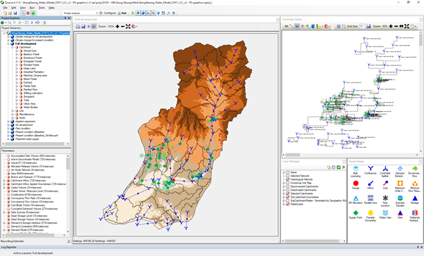
Through 2019-2020, funded by the World Bank, eWater, in collaboration with the Institute of Technology Cambodia (ITC) and Ministry of Water Resources and Meteorology (MOWRAM), and Ministry of Industry, Science, Technology and Innovation (MISTI) undertook a comprehensive catchment assessment in the Stung Staung River and developed a Source model to support dialogue on a water sharing plan in the catchment. The outcome of the assessment will support the design of future water supply infrastructure and investment potential of the RGC and the World Bank in Staung district.

Stung Staung River Source Model

Methodology

The data review included demography, geography, water sources, status and trends of water supply and demand, initial potential risks and mitigation measures.  Additional hydrometeorological datasets were collected to help refine the existing country-wide Source model to form the Source Stung Staung Model, the model supports hydrological and water system modelling. The hydrological model was used to undertake a water balance assessment that characterised the natural condition (rainfall-runoff process) in the catchment.  The water system model was run to quantify water demand from various sectors, mainly irrigation activities and municipal water requirements.

Once the hydrological characteristics for the catchment were defined, several future scenarios were formulated and later assessed using well calibrated models of the pre-development and future-development scenarios. This allowed for an assessment of potential hydrological risks. The simulations quantified surface water availability from the natural processes of rainfall-runoff and water resource use by different sectors. Hydrological baseline statistics were developed, which characterised the water supply/demand balance on a monthly, seasonal and annual basis.

Climate change impacts

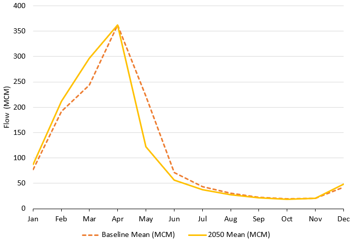
An analysis of rainfall patterns over the Stung Staung Catchment reveals an observed change in rainfall between the past condition (2000-2011) and the present condition (2012-2019). The pattern of mono-modal with a peak in September has changed to bi-modal with peaks in July and September. A decrease in rainfall in August was clearly observed for all the key stations. Particularly, a big change in rainfall was observed at Stoung in the lower section of the river. Monthly rainfall in the wet season dropped about 100 mm. A significant drop was in September: decreasing from about 400 mm to below 200 mm. The climate change assessments suggest a decrease in all flow ranges from the present condition.

Pathway to resilient water resources

The project allows the Cambodian authorities to consider the developed workflow and application of the Source Modelling Platform for water balance analysis and catchment assessment as a scientific tool to support water allocation mechanisms.

The study recommended, through community discussions, establishing a minimum requirement for water quantity and quality as the priority for domestic water supply. Understanding community priorities will assist the large water storage managers in developing an equitable water sharing plan for domestic and irrigation water.  While there is a potential for expansion of irrigation scale, the irrigation modernisation should be taken into account of water balance to improve the sustainability of the irrigation system, providing benefits to farmers and the downstream biodiversity and aquatic environment in the river. Crop intensification would lead to higher irrigation water demand resulting in water shortage so shifting the crop growing calendar could be considered as a way to ease water shortages in May and June.

With signs of less water available in the future, the villages in the river basin need to discuss their options, such as crop diversification to high value crops, which may generate greater income with less water. The study provides valuable details and guidance for the authorities and villagers in the river basin to mitigate risks and for Development Partners to investigate water resource development option and enhance water resource management benefits in the Stung Staung Basin.

Related information

Read this article by the CAVAC (Cambodia-Australia Agricultural Value Chain Program) for more on the use of water models in Cambodia https://cavackh.org/public/post/using-water-simulation-models-to-support-sustainable-water-resources-management


Paddock to Reef – Integrated Monitoring, Modelling and Reporting Program

Targeting investment to improve the health of the Great Barrier Reef.

What is the Paddock to Reef program?

The Paddock to Reef Integrated Monitoring, Modelling and Reporting Program (Paddock to Reef program) started in 2009 as a joint initiative of the Australian and Queensland governments to report on water quality improvement resulting from investment in improved land management practices. Improving the quality of water leaving properties by reducing pollutant run-off is critical to build the health and resilience of the Great Barrier Reef (GBR). The program brings together industry bodies, government agencies, natural resource management bodies, landholders and research organisations.

The program provides a framework for evaluating and reporting progress towards the Reef 2050 Water Quality Improvement Plan targets. It integrates monitoring and modelling information on management practices, catchment indicators, catchment loads and the health of the Reef at the paddock, sub-catchment, catchment, regional and whole GBR scales (image below). The program evaluates management practice adoption, management practice effectiveness (in terms of water quality benefits and economic outcomes), catchment condition, pollutant run-off and marine condition.

Focus areas for the Paddock to Reef program

How does Source support the program?

The catchment modelling for the program is based on the Source platform, with customised plug-ins developed by the Queensland Government to provide additional water quality functionality. A range of other purpose-built data collection and reporting tools have also been built to support the program. These include interactive maps to show pollutant generation rates and priority investment areas.

The models are primarily used to report on annual progress towards the reef water quality targets as a result of investment in improved land management practices. Model outputs are also used to determine priority areas for investment and to assess possible outcomes from different scenarios such as different rates of adoption of improved practices. The catchment models also provide inputs for the marine models.

The Paddock to the Reef program helps manage the impacts of landuse on the quality of water flowing to the Great Barrier Reef, Qld
(credit: WITTE-ART.com / Adobe Stock)

Information sharing

Many of the actions required to achieve the water quality targets need to be undertaken by farmers and other land managers. To support greater uptake of the required actions, the Paddock to Reef program has been designed to share technical information in a way that can be easily understood and used. It also incorporates the local knowledge of land managers. Program features include:

  • Multiple lines of evidence to inform progress towards the targets.
  • Technical experts are based in the regions, giving them a good understanding of the local environment, issues and the effectiveness of management actions. This also helps build relationships with local land managers.
  • Ongoing refinement of the models and other tools to incorporate new knowledge, data and methods.
  • Results are presented online through an interactive reporting system to cater for the broad range of stakeholders interested in the results from the general public to scientific experts.
  • Data is made available to support other programs, for example regional report cards and regional natural resource management body and local government investment decisions.
  • ‘Cut down’ models provide locally specific tools to assess individual projects and prioritise local investment.

Peer review, continual improvement and validation are critical elements for any modelling program. The Paddock to Reef catchment modelling program undertakes an external review every three years. The program is supported by a GBR-wide pollutant loads monitoring program which provides data to calibrate and validate the catchment models and increase confidence in the models over time.

For further information go to Reef 2050 Water Quality Improvement Plan website https://www.reefplan.qld.gov.au/tracking-progress

Acknowledgements

This case study was prepared in collaboration with the Queensland Department of Environment and Science.


Arghandab Integrated Water Resource Management Project – Afghanistan

Decades of war and political instability have decimated most of Afghanistan’s water infrastructure and reduced the technical capacity of the water resources sector. 

In response, the Government of the Islamic Republic of Afghanistan is undertaking a range of initiatives to invest in new infrastructure,  improve water resource management and increase capability. One such initiative is the Arghandab Integrated Water Resource Management Project. 

The Asian Development Bank (ADB) is supporting the Afghanistan Government to scope the Arghandab Integrated Water Resource Management Project. The project will finance infrastructure to increase water resources for irrigated agriculture, urban water supply, and power generation for Afghanistan’s second largest city Kandahar and surrounding areas.

Farmland in Kandahar (credit Paul/AdobeStock)

Using Source to support infrastructure investment

eWater was invited to provide technical assistance to the project, through a rapid hydrologic study of the Arghandab River and capacity building through training in the use of the Source modelling platform. eWater’s involvement was funded by the Australian Department of Foreign Affairs and Trade (DFAT). 

eWater, in collaboration with modellers in Afghanistan built a baseline Source model for the Arghandab River Basin. The model is used to generate inflows to Dahla Dam for the period 2002 to 2016. 

The model allows different multi-sector allocation scenarios for irrigation, urban water supply, hydropower and downstream flows to be compared against each other, providing key inputs to support the decision-making process. The potential impacts of climate change on the different options is considered by modelling different inflow scenarios. 

Overcoming data constraints

Water models typically rely on observed measurements for flow, rainfall, evaporation etc. However, such data is very limited in Afghanistan.  A combination of data from historic sources and remotely sensed sources were evaluated and used to develop the Source model. The hydrology is simulated using the GR4J and GR4JSG hydrological models which, respectively, represent direct rainfall-runoff and snow melt processes. The hydrology is calibrated to historic average monthly observed values.

Given that this is a rapid study where limited time is available to explore alternate sources of data such as some of the globally generated flow sequences used for detailed climate change modelling, an expedient approach to calibrating the model was adopted.  This was to assume stationarity in average monthly flows and calibrate to observed monthly average discharge values despite differences in dates between rainfall and discharge. This averaging impacts on the predictive ability of the model for extreme events such as flash flooding associated with sudden high rainfall since extreme peaks in flows can happen at a sub-monthly scale. 

Nonetheless, the model significantly increases the information available to water managers to understand current flows and support initial investigations into the impact of changes in dam size and demand over time and with climate change. Examples of the model outputs are shown below. 

Monthly flows

Flows are highly variable, particularly during the wet season. Monthly flows are lowest in October and November, and highest in April. The figure below shows the possible range in total monthly flows predicted by the Source model, with the grey area representing modelled minimum and maximum flows for each month. The modelled period 2002 – 2016 includes the drought years of 2010  2016 as well as extreme flows observed in 2007. Mean and median flows are also indicated.

Shows the total modelled monthly inflows to the Dahla Reservoir (2002 – 2016). Flows start increasing in December, peaking in April. Flows start falling through June and July, with virtually no flow from August to November.
Range in total modelled monthly inflows to the Dahla Reservoir (2002 – 2016)

Impact of climate change on flows

The projected impact of changes in temperature and rainfall on average total monthly inflows to Dahla Dam, between the baseline period (2002 – 2016) and future 2050 are illustrated in Figure X. Expected higher temperatures will cause snow to melt sooner in the season with an increase in flow in March and less water available from May resulting in a longer low flow season.

Average total monthly flow volumes (Baseline 2002 – 2016 and 2050)