Understanding the water resources of the Ayeyarwady Basin, Myanmar

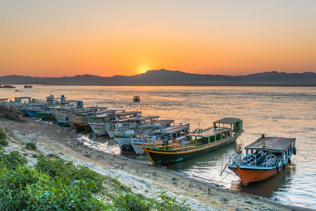
The Ayeyarwady River is Myanmar’s largest and most commercially important river but its water resources are not well understood.

With the support of the Australian Water Partnership, the Government of the Republic of the Union of Myanmar commissioned the first integrated assessment of the natural resources of the Ayeyarwady Basin. eWater lead the surface water assessment for the State of the Basin Assessment (SOBA).

The Ayeyarwady Basin

With an area of just over 675 000 km2, the Republic of the Union of Myanmar is the second largest country in South-East Asia, after Indonesia. 

The Ayeyarwady River starts in the Himalayas, flowing for approximately 2 000 km in a north-south direction through Central Myanmar. The river basin has a total area of 413,700 km2 and covers about 61% of Myanmar. About 5% of the Basin extends into the neighbouring countries of India (to the west) and China (to the east). 

The Ayeyarwady River Basin is dominated by a monsoonal rainfall regime, associated with the south-western Indian monsoon. It is also affected by convectional systems and cyclones from the Bay of Bengal. Groundwater flows to the streams and snowmelt from the northern regions are also important contributions to basin flows.  

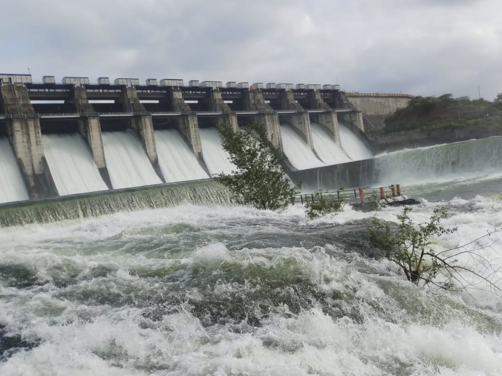
The Ayeyarwady River Basin is still a relatively undeveloped basin. Like the majority of Myanmar, most of the Basin is characterized as rural, with agriculture the main use of water. 

Ayeyarwady River, view from Bupaya bagan (credit: tuanjai62/ Adobe Stock)

Project overview

The SOBA provides a baseline assessment of the basin’s water and other natural resources, from which future management options can be compared against.

eWater developed a preliminary baseline Source water system model for the Ayeyarwady Basin (north of the delta), from which a baseline assessment of the basin’s surface water resources was undertaken.

The model is run with historic climate data for 1982 to 2016, land use in 2014 and storage capacity in 2016. It represents agriculture, domestic, urban and hydropower water use.

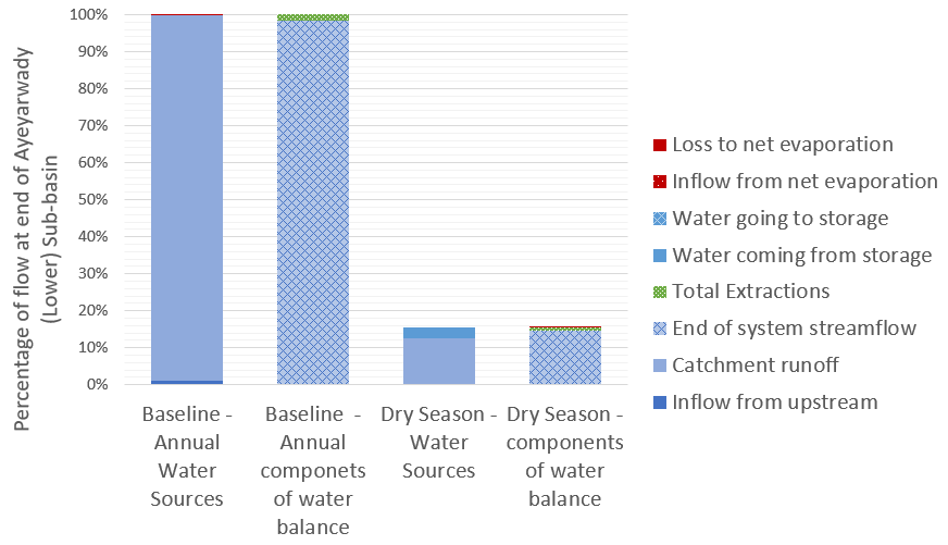
For the first time, the baseline assessment gives water managers a description of the hydrology of the Ayeyarwady River Basin according to 5 Hydro-Ecological Zones and 13 sub-basins, significantly increasing the understanding of both water availability and water use in the basin. For example, in the figure below, we can see the different components that contribute to flow at the end of the system as an annual total and during the critical dry season, it shows how much water is provided by different sources and how much of this water is used or lost to evaporation.

Flow components at the end of the Ayeyarwady Basin, annually and in the dry season

The water system model is a first cut at drawing together the information required to adequately understand and simulate the complexities of the Ayeyarwady River Basin. The baseline model will be a key tool to support the future management of the basin’s water resources, making it possible to:   

  • Combine outputs from the model together with observed values, to provide an overall assessment of water availability and uses across the Ayeyarwady River Basin.  
  • Understand baseline water availability and use, to support the ongoing assessment of the Basin’s water resources and to examine possible future scenarios and possible implications, for example with climate change or increased agricultural use. 
  • Simulate components of the hydrological cycle at locations where observed values are not available. 
  • Identify information gaps and inform future data collection initiatives. 

Scoping Study

Following the completion of the SOBA, eWater was engaged to undertake a scoping study of potential development options for the mainstream of the Ayeyarwady River and tributary flows. The study was also supported by the Australian Water Partnership.

The scoping study sought to demonstrate how water resource models can be used to assess management scenarios and provide valuable outputs to support stakeholder consultation.

The surface water system model was adapted to allow it to provide information on the likely changes in the Ayeyarwady mainstream and tributaries from different development scenarios. The scoping model can assess the likely flow changes from different development options, to consider the impact on water dependent outcomes such as irrigation, hydropower production, surface water flow heights and and flood magnitude. It is not intended to evaluate specific development proposals.

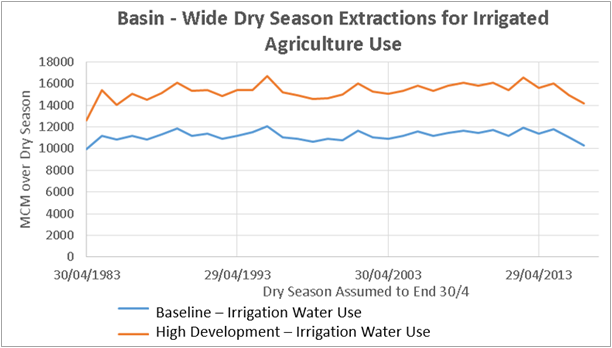
The scoping model was used to compare a High Development Scenario of hydropower on the tributaries and some irrigation development in the Central Dry Zone against a baseline scenario. The baseline scenario included ‘current’ irrigation demand and hydropower dams representing 2000 megawatts of hydropower, it does not include some 30 irrigation storages where data was not available.

The results compared include:

  • Change in hydropower generation on an annual and seasonal basis, inter-annual variability was also assessed. 
  • Agriculture water use and availability assessed on an annual and inter-annual basis. 
  • An assessment of changes to hydrographs at Sagaing, Pyay and Monywa, including changes in flow volume as well as surface water level.

An example of the scoping model outputs is shown below. In this, dry season irrigation extraction under the baseline and high development scenarios are compared.

Dry season demand for water under the baseline and high development scenarios.

Capacity Building

eWater conducted face to face training programs to introduce water managers in Myanmar to the principles of hydrological modelling and the use of Source. The training used the new Ayeyarwady Source model, providing participants with hands-on experience in the use of the model.

eWater’s Geoff Davis presenting Source training in Myanmar


Paddock to Reef – Integrated Monitoring, Modelling and Reporting Program

Targeting investment to improve the health of the Great Barrier Reef.

What is the Paddock to Reef program?

The Paddock to Reef Integrated Monitoring, Modelling and Reporting Program (Paddock to Reef program) started in 2009 as a joint initiative of the Australian and Queensland governments to report on water quality improvement resulting from investment in improved land management practices. Improving the quality of water leaving properties by reducing pollutant run-off is critical to build the health and resilience of the Great Barrier Reef (GBR). The program brings together industry bodies, government agencies, natural resource management bodies, landholders and research organisations.

The program provides a framework for evaluating and reporting progress towards the Reef 2050 Water Quality Improvement Plan targets. It integrates monitoring and modelling information on management practices, catchment indicators, catchment loads and the health of the Reef at the paddock, sub-catchment, catchment, regional and whole GBR scales (image below). The program evaluates management practice adoption, management practice effectiveness (in terms of water quality benefits and economic outcomes), catchment condition, pollutant run-off and marine condition.

Focus areas for the Paddock to Reef program

How does Source support the program?

The catchment modelling for the program is based on the Source platform, with customised plug-ins developed by the Queensland Government to provide additional water quality functionality. A range of other purpose-built data collection and reporting tools have also been built to support the program. These include interactive maps to show pollutant generation rates and priority investment areas.

The models are primarily used to report on annual progress towards the reef water quality targets as a result of investment in improved land management practices. Model outputs are also used to determine priority areas for investment and to assess possible outcomes from different scenarios such as different rates of adoption of improved practices. The catchment models also provide inputs for the marine models.

The Paddock to the Reef program helps manage the impacts of landuse on the quality of water flowing to the Great Barrier Reef, Qld
(credit: WITTE-ART.com / Adobe Stock)

Information sharing

Many of the actions required to achieve the water quality targets need to be undertaken by farmers and other land managers. To support greater uptake of the required actions, the Paddock to Reef program has been designed to share technical information in a way that can be easily understood and used. It also incorporates the local knowledge of land managers. Program features include:

  • Multiple lines of evidence to inform progress towards the targets.
  • Technical experts are based in the regions, giving them a good understanding of the local environment, issues and the effectiveness of management actions. This also helps build relationships with local land managers.
  • Ongoing refinement of the models and other tools to incorporate new knowledge, data and methods.
  • Results are presented online through an interactive reporting system to cater for the broad range of stakeholders interested in the results from the general public to scientific experts.
  • Data is made available to support other programs, for example regional report cards and regional natural resource management body and local government investment decisions.
  • ‘Cut down’ models provide locally specific tools to assess individual projects and prioritise local investment.

Peer review, continual improvement and validation are critical elements for any modelling program. The Paddock to Reef catchment modelling program undertakes an external review every three years. The program is supported by a GBR-wide pollutant loads monitoring program which provides data to calibrate and validate the catchment models and increase confidence in the models over time.

For further information go to Reef 2050 Water Quality Improvement Plan website https://www.reefplan.qld.gov.au/tracking-progress

Acknowledgements

This case study was prepared in collaboration with the Queensland Department of Environment and Science.


How Source supports the management of the Murray-Darling Basin

The Murray–Darling Basin is the largest and most complex river system in Australia. It runs through four States and one Territory and has a river network of 77,000 kilometres.

The Basin is home to more than 2.6 million people and has significant economic, cultural, social, and environmental values.  Agriculture in the basin produces $24 billion annually, its waterways provide clean drinking water to 3 million people and its unique environment is home to 120 species of waterbirds and 46 species of native fish.

Modelling plays an important role in supporting the management of the Murray-Darling Basin. The need for a modelling platform that could be used across the basin’s diverse river systems was a key driver behind the National Hydrology Modelling Strategy.  This case study highlights some of the ways Source models are used by the Murray-Darling Basin Authority (MDBA).

Water resource planning

The MDBA, in partnership with the River Murray States, have built a Source model to support water resource planning in the River Murray and lower Darling river systems. The Source Murray Model (SMM) is based on a daily timestep and includes:

  • system inflows
  • flow routing and losses
  • irrigation, stock and domestic, town water supply and environmental demands
  • inter-state water sharing, allocation and ownership
  • definition of State Water access rights, allocation and accounting
  • water trade
  • water ordering and the operation of dams and infrastructure
  • salt transport.
The Source Murray Model, is one of the most complex Source models built to date.

The SMM allows the MDBA and Basin States to test policy and management options and observe the likely impacts changes may have on the system, such as possible changes to State water shares or the reliability of supply to water users, compliance with the Basin Plan or to manage river salinity levels. Options can be compared against four standard planning scenarios:

  • Without Development – removes consumptive diversions and regulating infrastructure (dams, weirs, offtake regulators etc.) to estimate what might have happened without regulation
  • Baseline Diversion Limit – represents the best estimate of conditions at June 2009, this scenario is used to define the Baseline conditions under the Murray-Darling Basin Plan (Basin Plan)
  • Current Conditions – represents the best estimate of the current management and operation of the Murray and lower Darling rivers
  • BSM2030 – represents the process used to calculate and maintain the salinity registers, which are central to the joint management of salinity in the River Murray system under the Basin Salinity Management 2030 strategy.

River operations

The MDBA is responsible for managing the River Murray and lower Darling rivers in accordance with a long-standing agreement between the Australian Government and the Basin states. As part of this, the MDBA implements water sharing arrangements, manages water infrastructure and delivers water to meet irrigation, stock and domestic, urban water supply and environmental demands.

To do this, the MDBA must understand:

  • how much water is in the systems dams
  • current and forecast river flows
  • inflows from tributaries, including water trade
  • how much water will be lost to evaporation and seepage
  • demand for water along the length of the river system
  • system constraints and operating rules

For many years the MDBA has used a spreadsheet model to support its river operations. Together with eWater, the MDBA has built a Source operations model to replace these spreadsheets. This source model is currently being tested before adoption. On completion of this testing, the model will give river operators a much more powerful management tool, allowing them to readily plan for operations under many different scenarios and to simulate the potential impacts of different operational decisions, on a daily and seasonal basis.

Hume Dam, NSW – is key to river operations in the River Murray (credit: Hypervision/Adobe Stock)

Environmental flow modelling

Over the last decade, significant volumes of water in the Murray-Darling Basin have been set aside for environmental purposes. Managing and delivering this water provides a range of new challenges for water managers. 

The MDBA, Commonwealth Environmental Water Holder, then New South Wales Office of Environment and Heritage, Victorian Department of Environment, Lands, Water and Planning, and the South Australian Department for Environment and Water collaborated with eWater to better enhance environmental water modelling functionality in Source, through the:

  • environmental flow node – defines environmental flow demands based on a range of criteria, such as frequency, duration or magnitude of flows or event triggers
  • environmental water manager – to compare and prioritise different environmental demands, both spatially and temporally, subject to environmental water allocations.

This functionality allows river operators and environmental water managers to model different flow scenarios, to compare potential environmental benefits, understand the possible impacts on river operations and identify opportunities to boost environmental outcomes by combining with other water deliveries.  

Managing salt

Large areas of the Basin are underlain by ancient marine sediments. Land clearing and water intensive farming has brought saline groundwater closer to the surface and into the river system. Increased water use has reduced river flows, resulting in less water to dilute the salt or flush it out to sea.

High salt levels can have serious implications for water quality, plant growth, land productivity, biodiversity, and the supply of water for human and animal needs. Managing the impacts of salinity is one of the most significant challenges in the Basin. Since the 1960s, governments and communities have worked to manage salt through improved land management practices and infrastructure. In 2015, the MDBA and Basin States launched the Basin Salinity Management 2030 strategy, which sets out how governments are working to address salinity and meet agreed targets. 

Modelling underpinned the development of the strategy and will be a key part of its implementation. The SMM was used to understand baseline flows and to set agreed salinity targets. The model can also be used to test different management actions and how these might affect salt loads and salinity, and achieving the aims of the strategy. Using the SSM, baseline salt loads can be determined and to assess how these might be affected by different flow regimes or management actions. Figure 2 provides an example of the model outputs, it compares historic, current and benchmark salt loads. 

The SSM is an important tool for understanding salt loads, in this example historic, benchmark and current salt loads are compared.

This case study was prepared in collaboration with the Murray-Darling Basin Authority


River Basin Models and Water Sharing Policy in the upper Godavari Sub-Basin, Maharashtra, India

Resolving tension between farmers upstream and downstream over water allocations in the upper Godavari River in Maharashtra was the focus of a four year engagement in the west Indian State by eWater.

The Maharashtra and New South Wales governments signed a Memorandum of Understanding for cooperation across a wide range of issues.  Under the provisions of this MOU, the Government of Maharashtra in partnership with the NSW Department of Industry, Lands and Water (then) engaged eWater to provide training, technology transfer, and ongoing support in the use of Australian river modelling technology to Maharashtra.

eWater assisted the Maharashtra Department of Water Resources to develop a modelling framework to test water management options and to support the development of an integrated water resources management (IWRM) plan for the Upper Godavari sub-basin.

Basin overview

The Godavari River basin is India’s second largest river basin, it covers 50% of the land area of Maharashtra state.  It is a complex system, with 20 dams. Water use includes irrigated crops, industry and domestic use in urban and rural areas, including drinking water.  Water availability and equitable distribution of water within the sub-basin are major public concerns that have resulted in legal challenges.

Within the sub-basin there is significant spatial and inter-annual variability in monsoon rainfall. Typically, runoff is generated in the high-rainfall, high-elevation areas of the sub-basin with little runoff generation in the area near the large Paithan irrigation dam at the outlet of the Upper Godavari. 

Paithan Dam, after upstream monsoon rains.

Project outcomes

The project had two primary outputs, a calibrated Source model for the Upper Godavari Sub-Basin and building the capacity of the Maharashtra Department of Water Resources.

eWater, in collaboration with modellers from the Maharashtra Department of Water Resources set-up and calibrated a Source model for the Upper Godavari sub-basin. The model was used to evaluate water management options to improve equitable access to water across the sub-basin. Model outputs were used to inform the integrated water resource management plan

eWater and the NSW Department of Industry, Lands and Water used outputs from the river basin models to establish and focus communication and discussion with the Maharashtra Water Resources Department about improved water management policies and governance processes to implement the objectives of the Maharashtra State Water Policy. With a key focus being improving targeted communications to farmers in the basin.

eWater delivered a comprehensive training program in the use of Source, with customised training based on the Upper Godavari model. Training was held in India and Australia, both involved a combination of hands-on desktop learning and field visits to better understand the linkages between models and on-ground water management. 

More broadly, the project brought together water managers, academics and researchers in the Upper Godavari sub-basin to establish a community of practice that allows lessons and experiences to be shared across other sub-basins in Maharashtra.

Delegates learning about modern irrigation technology in the Murray-Darling Basin.

Award winning project

The success of the project was recognized at India Water Week 2019, when the national Minister for Jal Shakti (Water Resources) presented an award to the Maharashtra Water Resources Department (WRD) for using eWater Source modelling framework to achieve equitable distribution of water in the Upper Godavari Sub-basin.

Left to right: Mr Arun Ghate (IWRM team GMIDC), Mr Jasing Hire (IWRM team GMIDC), Mr Ajay Kohirkar (Executive Director GMIDC), Mr Dilip Tawar (Chief Engineer GMIDC), Mr Rajendra Pawar (Secretary Command Area Development, WRD), Ms. Sonali Nagargoje (IWRM team GMIDC), Mr. Avirat Chavan (IWRM team GMIDC)