Customising Source to manage blackwater risks
Construction of dams, weirs and use of water for irrigation, industry and towns has meant that many aquatic and floodplain ecosystems don’t get the water they did naturally.
One way of addressing this is to construct infrastructure, such as regulators and embankments that allow water managers to simulate natural watering regimes with lower flows.
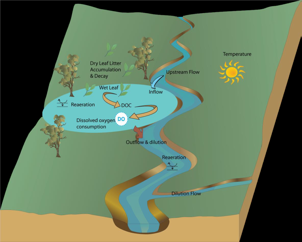
While inundation brings a range of ecological benefits, it also has the potential to cause hypoxic blackwater (low dissolved oxygen) events. Blackwater events occur when inundation washes organic material from the floodplains into waterways leading to a rise in dissolved organic carbon in the water. This causes the water to turn a dark colour. The increased bacterial activity breaking down the carbon consumes oxygen, which causes a drop in levels of dissolved oxygen. In some circumstances, levels can drop so much that fish and other aquatic organisms do not have enough oxygen and die.
Blackwater can also create challenges for downstream water use, such as increasing treatment costs for drinking water supplies.
Blackwater events are a natural feature of many river systems. However, when natural flood patterns are changed and there are longer periods between overbank flows, the amount of organic material can be substantially increased, exacerbating the risk.
The project
As part of the South Australian Riverland Floodplain Integrated Infrastructure Program (SARFIIP), the South Australian and Commonwealth governments have invested in major infrastructure upgrades to provide water to the Pike and Katarapko floodplains. The infrastructure allows the Department for the Environment and Water (DEW) to create higher water levels to inundate the wetlands, improving watering frequency and the ecological health of the floodplains.The project includes a number of initiatives to manage potential blackwater risks. This has included developing a model to help understand and predict dissolved oxygen responses to different inundation events, giving DEW important information to design watering events with reduced risk of blackwater events occurring.
Spreadsheet models were previously used to help understand blackwater risks (Howitt et al. 2007, Whitworth and Baldwin 2016, known as the Blackwater Risk Assessment Tool – BRAT). While effective for non-complex situations, DEW was unable to represent realistic hydrology, such as events where water flowed into and out of different floodplains along the river. A more sophisticated approach was required. DEW determined the best approach to be to develop a Source plugin to model blackwater processes on the floodplains.
DEW and the Murray-Darling Basin Authority use the Source modelling framework to help manage the River Murray System. The Source framework uses “plugins” as a flexible way to build additional modelling capability into model. Combined with the South Australian Source Murray Model, the new Blackwater plugin allows DEW to model interactions between the river and floodplains and the different processes that contribute to the risk of blackwater events.
The approach
Conceptually, the model is based on the original spreadsheet models and represents the key influences on the generation of blackwater events (from SMEC 2015):
- time period since the last inundation
- the duration and rate of inundation
- water exchange during inundation
- temperature
- area of inundation
- litter loading
- depth of inundation
- influence of floodplain creeks on dilution
- river dilution flows and proximity to environmental values
In addition, the model includes location specific information such as elevation, floodplain area and litter accumulation (from vegetation type), to understand the extent of inundation and litter accumulation.
The blackwater plugin is set up to represent all of the River Murray in South Australia, to consider interactions between the river and floodplains, as well as cumulative effects from multiple operations being inundated at the same time.
Model performance
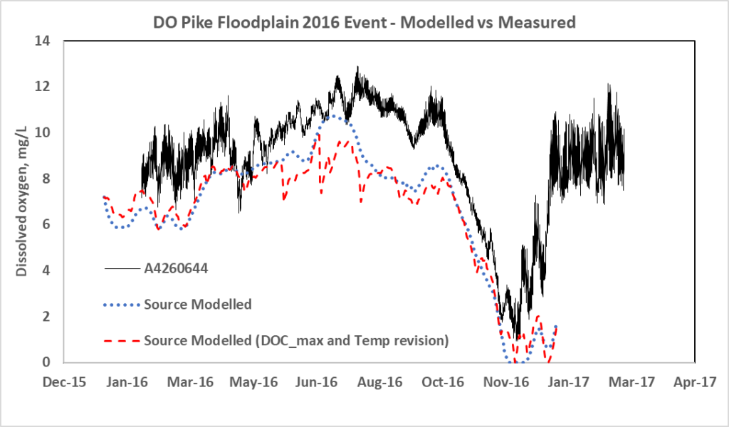
Model performance was tested in two ways. Firstly, simple floodplain scenarios were run through the Blackwater Risk Assessment Tool (BRAT) and the plugin. The results were comparable.
Secondly, a natural high flow event that inundated the Pike Floodplain in late 2016/early 2017 provided an opportunity to compare the model performance against observed DO data. The model compared well with the measured DO trends and magnitude but further testing under a wider range of scenarios is required to fully test the model. Notably, the event shows the importance of interactions with the river during blackwater events, as the majority of the DO decrease on the floodplain during Oct-Nov 2016 appears to relate to the low DO in the inflow water.
Implementation
The model supports DEW to:
- understand the potential DO changes associated with different environmental watering actions on the floodplains
- adjust proposed watering actions to reduce the risk of blackwater events
- forecast potential DO changes and blackwater risks from floods, and to identify potential river operations to minimise forecast blackwater events.
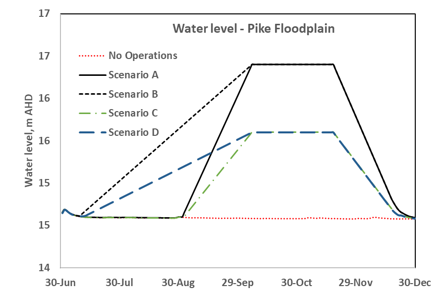
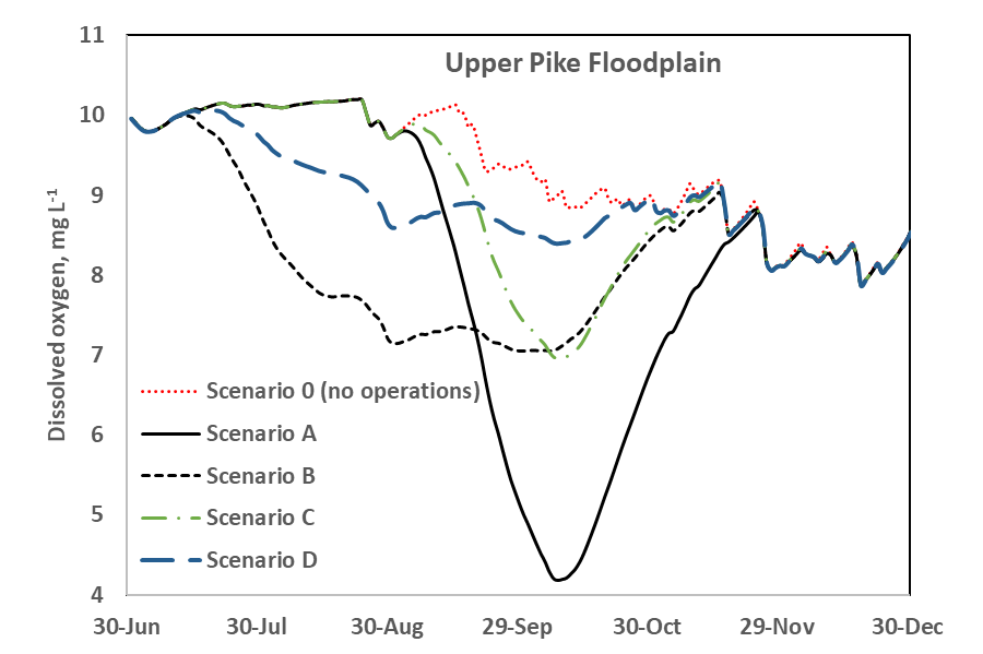
The figures below are two examples of the blackwater plugins outputs. The first shows the range of floodplain inundation under five different scenarios. The second shows forecast dissolved oxygen levels for each of the scenarios.
Project partners
This work forms part of the $155 million South Australian Riverland Floodplains Integrated Infrastructure Program (SARFIIP) to improve the health and resilience of Riverland floodplains. SARFIIP is funded by the Australian Government through the Murray–Darling Basin Authority and implemented by DEW in partnership with SA Water.
The Blackwater Plugin was developed for DEW by the University of Adelaide and Flow Matters Pty Ltd. eWater was engaged by DEW to further develop functionality and modify the plugin to better work with improvements made to the Source platform after the plugin was developed.
References
Howitt JA, Baldwin DS, Rees GN and Williams JL (2007). Modelling blackwater: predicting water quality during flooding of lowland river forests. Ecological Modelling 203 (3–4):229–242. doi:10.1016/j.ecolmodel.20
SMEC (2015). SARFIIP Blackwater Risk Assessment: Stage 1. Report to the Department of Environment, Water and Natural Resources. SMEC, Adelaide in association with Natural Logic (Karla Billington) and University of Adelaide (Luke Mosley)
Whitworth KL, Baldwin DS (2016). Improving our capacity to manage hypoxic blackwater in lowland rivers: the Blackwater Risk Assessment Tool. Ecological Modelling 320, 292–298. 06.11.017
Acknowledgements
This case study was prepared in collaboration with the SA Department for Environment and Water and Murray-Darling Basin Authority.