eWater Group and its partnership with Mekong River Commission

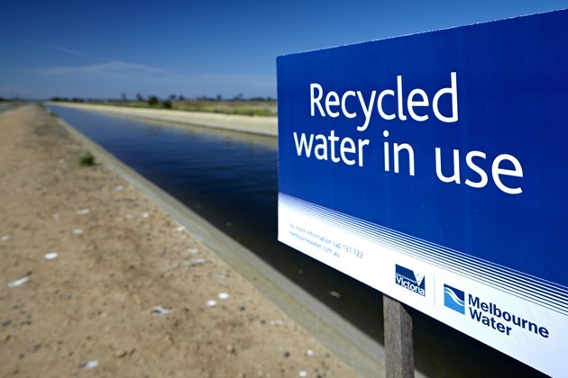
Australia has a long and proud history of supporting water resource management in the Mekong region.

eWater Group’s three divisions – eWater Solutions, Australian Water Partnership, and Mekong Water Solutions – play a critical role in sharing Australia’s technology and helping to build capabilities in the region.

Australia has been a partner of the Mekong River Commission (MRC) since its inception in 1995.  The MRC is an intergovernmental organisation, established “to help the lower Mekong countries build consensus around solutions that ensure a sustainable future for the Mekong and its people through basin monitoring, assessment, data and information sharing, and dialogue and cooperation.”

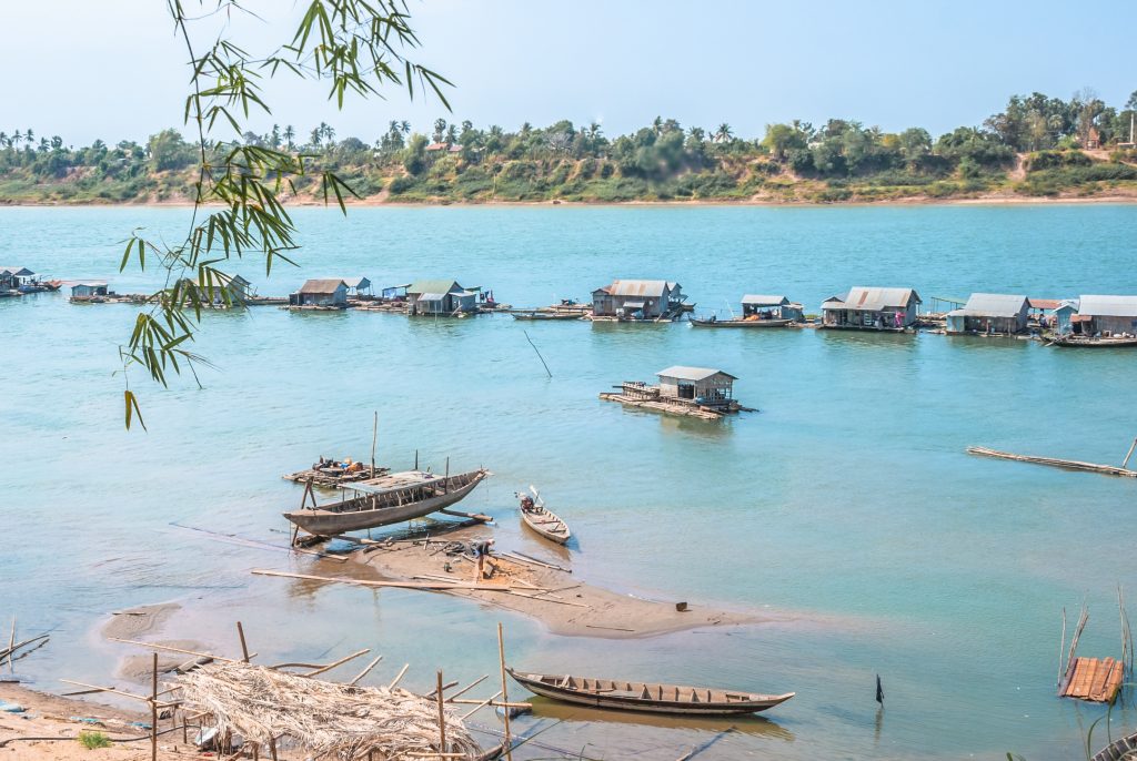
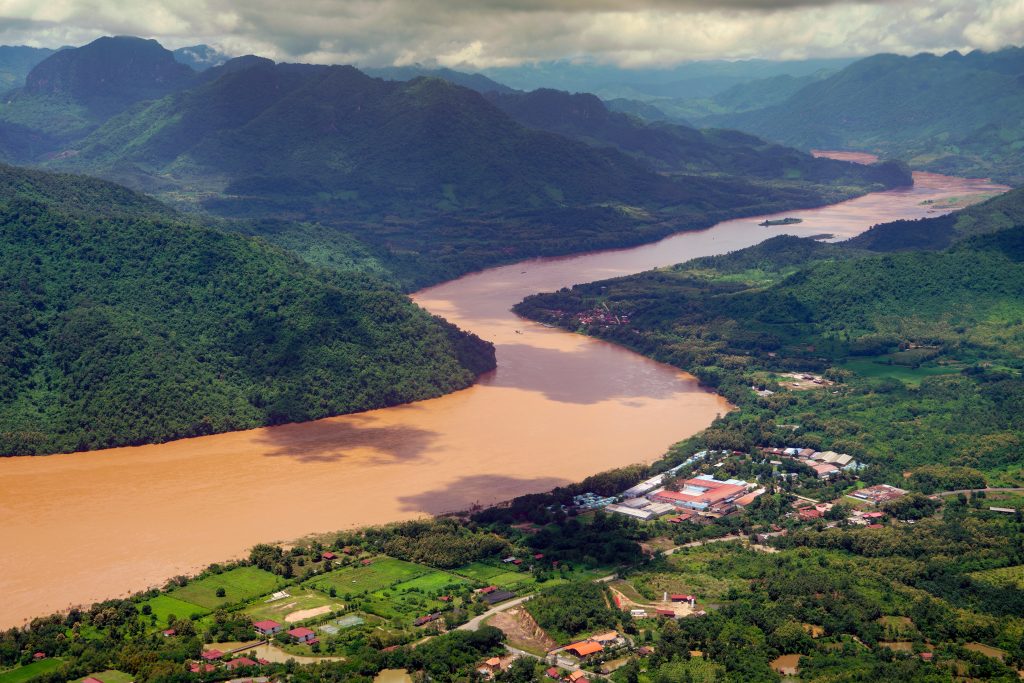
Since 2013, eWater Group has supported the Vientiane-based MRC and its four member countries (Cambodia, Laos, Thailand, and Vietnam) to enhance the management of the Mekong River’s water for the benefit of all who depend on it.

So how do we support the MRC?

Through the Australian Water Partnership, Australia has mobilised assistance on a range of strategically important issues including sustainable hydropower, regional flood and drought management, and management of fisheries in the rapidly developing river. Several Australian organisations are involved in delivering technical and capacity development support as part of Australia’s long-standing partnership.

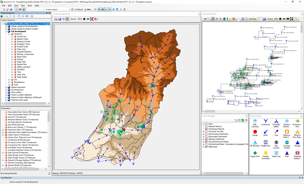
Through eWater Solutions, we have helped the MRC to increase their understanding of inflows into the river and the impacts of dams in the river basin on flow levels and sediment transportation through our flagship software product, eWater Source. This world-class science and technology platform is playing a key role in delivering several elements of the MRC 2021-2025 Strategic Plan, including the report on low flow and drought conditions in 2019-2021, the Joint Study between MRC and Lancang-Mekong Cooperation Water Centre on Changing Pattern of Hydrological Conditions in the Lancang-Mekong River Basin and enhancements to the MRC’s Flood/Drought webpage to better integrate data and communicate vital information on river flows.

For our Solutions team, recent activities have included:

  • advice on quality control procedures for incorporating hydromet (water and meteorology) data into MRC systems, to better inform day-to-day operations and provide faster response times;
  • advice on the implementation of the MRC Procedures for data, water use and flow monitoring;
  • supporting the initiative of the MRC Document Management System to ensure experience and knowledge from the past informs future planning;
  • contributing to the report on low flow and drought conditions in 2019-2021, which was well received by international stakeholders;
  • upgrading the Mekong Source model to incorporate new information, such as the storage strategies of reservoirs, in preparation for the Joint Study between MRC and Lancang-Mekong Cooperation Water Centre on Changing Pattern of Hydrological Conditions in the Lancang-Mekong River Basin;
  • coordinating and consolidating technical inputs from both the MRC and Lancang-Mekong Cooperation Water Centre team members into the report of the Joint study;
  • enhancing the MRC’s Flood/Drought webpage to better integrate data and communicate vital information on river flows.

According to eWater Group’s Principal Hydrologist and Mekong Team Leader, Dr Paradis Someth, “the success of eWater’s involvement with the MRC has been due to visionary leadership and trust of both parties and our work being clearly and directly aligned with the MRC Strategic Plan, which has ensured support from across the MRC Secretariat and relevant stakeholders.”

“Our collaborative partnership, with its strong focus on advice and coaching for staff in MRCS and member countries, has helped to develop the necessary skills and expertise to improve management of the Mekong River,” Dr Someth said.

For Australian Water Partnership General Manager, Sarah Ransom, “the long-term partnership with the Mekong River Commission represents shared trust with one another, and a shared interest in sustainable management and development of water resources in the Mekong basin. We look forward to continuing our support in the region.”

Over this period, eWater has enjoyed close working relations with the MRC Secretariat Leadership team and DFAT’s Mekong regional water team. 


Improving Livelihoods in Northern Cambodia

More than 300,000 people living in Stung Staung river basin in Northern Cambodia rely on agriculture for their livelihoods. Access to a clean water supply is fundamental for wellbeing and health particularly to prevent transmission of the COVID-19 virus. Increased food security, higher income for farmers and improved health in the villages can be expected if the reliability and quality of water supplies in the province can be enhanced through improved sharing of existing water supplies.

Partnering with the World Bank and support from the Royal Government of Cambodia (RGC), eWater undertook a study to assess the challenges of water supply development and to establish an enabling environment, based on scientific evidence, for a water sharing dialogue between authorities, farmers and relevant water users and assist with developing a long-term investment plan for water supply utility for Staung district in Kompong Thom Province.

(AdobeStock, Rice worker planting rice in a rice field, by Michel)

Study Area

The Stung Staung river rises in the mountains of Northern Cambodia before flowing 213 km to the iconic Lake Tonle Sap, one of the largest freshwater lakes in the world. In its northern reaches, the river flows through forest before entering expansive cropland to the south.  The majority of the 217 villages in the catchment are along the river in the farming districts which cover about a third of the catchment.  More than a quarter of the people in the river basin live in poverty.

Competition between irrigation and village water supplies is increasing as climate change varies the annual rainfall pattern. Barrage ‘Samsep Kagna’ of 7,200 ha is the only large irrigation scheme in the catchment. Other existing schemes include 17 medium schemes and 8 small schemes (Figure 1). Currently, rainfed paddy rice is the main crop in the command areas, but further downstream field and garden crops are more common.

Figure 1: Irrigation schemes and water supply utility in the Stung Staung Catchment.

To help manage the water competition and cope with climate change, a large water reservoir of the Staung Water Resource Development Project with a potential area of 30,000 ha is planned.

Clean water supply in the coverage areas comes from the Stung Staung River, supplemented with groundwater from a 200m deep tube well next to the treatment plant near the river.  A World Bank’s Water Supply and Sanitation Improvement Project (WaSSIP) aims to increase water supplies to villages by up to four times through a new water supply utility near Barrage ‘Samsep Kagna’.

Development of a Source model to assess demand and supply

Through 2019-2020, funded by the World Bank, eWater, in collaboration with the Institute of Technology Cambodia (ITC) and Ministry of Water Resources and Meteorology (MOWRAM), and Ministry of Industry, Science, Technology and Innovation (MISTI) undertook a comprehensive catchment assessment in the Stung Staung River and developed a Source model to support dialogue on a water sharing plan in the catchment. The outcome of the assessment will support the design of future water supply infrastructure and investment potential of the RGC and the World Bank in Staung district.

Stung Staung River Source Model

Methodology

The data review included demography, geography, water sources, status and trends of water supply and demand, initial potential risks and mitigation measures.  Additional hydrometeorological datasets were collected to help refine the existing country-wide Source model to form the Source Stung Staung Model, the model supports hydrological and water system modelling. The hydrological model was used to undertake a water balance assessment that characterised the natural condition (rainfall-runoff process) in the catchment.  The water system model was run to quantify water demand from various sectors, mainly irrigation activities and municipal water requirements.

Once the hydrological characteristics for the catchment were defined, several future scenarios were formulated and later assessed using well calibrated models of the pre-development and future-development scenarios. This allowed for an assessment of potential hydrological risks. The simulations quantified surface water availability from the natural processes of rainfall-runoff and water resource use by different sectors. Hydrological baseline statistics were developed, which characterised the water supply/demand balance on a monthly, seasonal and annual basis.

Climate change impacts

An analysis of rainfall patterns over the Stung Staung Catchment reveals an observed change in rainfall between the past condition (2000-2011) and the present condition (2012-2019). The pattern of mono-modal with a peak in September has changed to bi-modal with peaks in July and September. A decrease in rainfall in August was clearly observed for all the key stations. Particularly, a big change in rainfall was observed at Stoung in the lower section of the river. Monthly rainfall in the wet season dropped about 100 mm. A significant drop was in September: decreasing from about 400 mm to below 200 mm. The climate change assessments suggest a decrease in all flow ranges from the present condition.

Pathway to resilient water resources

The project allows the Cambodian authorities to consider the developed workflow and application of the Source Modelling Platform for water balance analysis and catchment assessment as a scientific tool to support water allocation mechanisms.

The study recommended, through community discussions, establishing a minimum requirement for water quantity and quality as the priority for domestic water supply. Understanding community priorities will assist the large water storage managers in developing an equitable water sharing plan for domestic and irrigation water.  While there is a potential for expansion of irrigation scale, the irrigation modernisation should be taken into account of water balance to improve the sustainability of the irrigation system, providing benefits to farmers and the downstream biodiversity and aquatic environment in the river. Crop intensification would lead to higher irrigation water demand resulting in water shortage so shifting the crop growing calendar could be considered as a way to ease water shortages in May and June.

With signs of less water available in the future, the villages in the river basin need to discuss their options, such as crop diversification to high value crops, which may generate greater income with less water. The study provides valuable details and guidance for the authorities and villagers in the river basin to mitigate risks and for Development Partners to investigate water resource development option and enhance water resource management benefits in the Stung Staung Basin.

Related information

Read this article by the CAVAC (Cambodia-Australia Agricultural Value Chain Program) for more on the use of water models in Cambodia https://cavackh.org/public/post/using-water-simulation-models-to-support-sustainable-water-resources-management


Understanding the water resources of the Ayeyarwady Basin, Myanmar

The Ayeyarwady River is Myanmar’s largest and most commercially important river but its water resources are not well understood.

With the support of the Australian Water Partnership, the Government of the Republic of the Union of Myanmar commissioned the first integrated assessment of the natural resources of the Ayeyarwady Basin. eWater lead the surface water assessment for the State of the Basin Assessment (SOBA).

The Ayeyarwady Basin

With an area of just over 675 000 km2, the Republic of the Union of Myanmar is the second largest country in South-East Asia, after Indonesia. 

The Ayeyarwady River starts in the Himalayas, flowing for approximately 2 000 km in a north-south direction through Central Myanmar. The river basin has a total area of 413,700 km2 and covers about 61% of Myanmar. About 5% of the Basin extends into the neighbouring countries of India (to the west) and China (to the east). 

The Ayeyarwady River Basin is dominated by a monsoonal rainfall regime, associated with the south-western Indian monsoon. It is also affected by convectional systems and cyclones from the Bay of Bengal. Groundwater flows to the streams and snowmelt from the northern regions are also important contributions to basin flows.  

The Ayeyarwady River Basin is still a relatively undeveloped basin. Like the majority of Myanmar, most of the Basin is characterized as rural, with agriculture the main use of water. 

Ayeyarwady River, view from Bupaya bagan (credit: tuanjai62/ Adobe Stock)

Project overview

The SOBA provides a baseline assessment of the basin’s water and other natural resources, from which future management options can be compared against.

eWater developed a preliminary baseline Source water system model for the Ayeyarwady Basin (north of the delta), from which a baseline assessment of the basin’s surface water resources was undertaken.

The model is run with historic climate data for 1982 to 2016, land use in 2014 and storage capacity in 2016. It represents agriculture, domestic, urban and hydropower water use.

For the first time, the baseline assessment gives water managers a description of the hydrology of the Ayeyarwady River Basin according to 5 Hydro-Ecological Zones and 13 sub-basins, significantly increasing the understanding of both water availability and water use in the basin. For example, in the figure below, we can see the different components that contribute to flow at the end of the system as an annual total and during the critical dry season, it shows how much water is provided by different sources and how much of this water is used or lost to evaporation.

Flow components at the end of the Ayeyarwady Basin, annually and in the dry season

The water system model is a first cut at drawing together the information required to adequately understand and simulate the complexities of the Ayeyarwady River Basin. The baseline model will be a key tool to support the future management of the basin’s water resources, making it possible to:   

  • Combine outputs from the model together with observed values, to provide an overall assessment of water availability and uses across the Ayeyarwady River Basin.  
  • Understand baseline water availability and use, to support the ongoing assessment of the Basin’s water resources and to examine possible future scenarios and possible implications, for example with climate change or increased agricultural use. 
  • Simulate components of the hydrological cycle at locations where observed values are not available. 
  • Identify information gaps and inform future data collection initiatives. 

Scoping Study

Following the completion of the SOBA, eWater was engaged to undertake a scoping study of potential development options for the mainstream of the Ayeyarwady River and tributary flows. The study was also supported by the Australian Water Partnership.

The scoping study sought to demonstrate how water resource models can be used to assess management scenarios and provide valuable outputs to support stakeholder consultation.

The surface water system model was adapted to allow it to provide information on the likely changes in the Ayeyarwady mainstream and tributaries from different development scenarios. The scoping model can assess the likely flow changes from different development options, to consider the impact on water dependent outcomes such as irrigation, hydropower production, surface water flow heights and and flood magnitude. It is not intended to evaluate specific development proposals.

The scoping model was used to compare a High Development Scenario of hydropower on the tributaries and some irrigation development in the Central Dry Zone against a baseline scenario. The baseline scenario included ‘current’ irrigation demand and hydropower dams representing 2000 megawatts of hydropower, it does not include some 30 irrigation storages where data was not available.

The results compared include:

  • Change in hydropower generation on an annual and seasonal basis, inter-annual variability was also assessed. 
  • Agriculture water use and availability assessed on an annual and inter-annual basis. 
  • An assessment of changes to hydrographs at Sagaing, Pyay and Monywa, including changes in flow volume as well as surface water level.

An example of the scoping model outputs is shown below. In this, dry season irrigation extraction under the baseline and high development scenarios are compared.

Dry season demand for water under the baseline and high development scenarios.

Capacity Building

eWater conducted face to face training programs to introduce water managers in Myanmar to the principles of hydrological modelling and the use of Source. The training used the new Ayeyarwady Source model, providing participants with hands-on experience in the use of the model.

eWater’s Geoff Davis presenting Source training in Myanmar


Revitalising Adelaide’s drainage reserves

Revitalised Reserves Connecting Communities

Designing a Stormwater System for an Urban Biodiversity Corridor

The drainage reserves that run diagonally through Pasadena from the Adelaide Hills to the Plains are hot, dry and barren.

On an urban heat map (right), the reserves show up as the hottest areas in the locality, scarring the otherwise leafy suburb. Due to open unirrigated bare ground, the reserves contribute more urban heat island impacts than surrounding roads and structures.

The site is near a popular shopping centre, important recreation areas and in an area destined for further urban infill. A radically different passive recreation space is needed to serve the community both now and into the future, and climate change makes quality open spaces rarer.

Revitalising Reserves with a Biodiversity Corridor

Water Technology completed a conceptual design of a multi-function stormwater system for a new Biodiversity Corridor. The stormwater system diverts runoff into a number of underutilised reserves within the City of Mitcham in the Adelaide foothills.

The project revitalises the reserves by providing much-needed water for irrigation and new native tree plantings. This is achieved by daylighting urban stormwater runoff from underground pipes into open channels within the reserves and diverting runoff to infiltration trenches for passive irrigation.

In this way, stormwater management will help deliver multiple benefits, including improving public health, local biodiversity, and providing a green and open space for the local community to reconnect.

eWater MUSIC was a key Water Sensitive Urban Design conceptual design tool used for the project. eWater MUSIC allowed engineers to model multiple stormwater management functions and evaluate the resulting multiple benefits of the Biodiversity Corridor.

The Biodiversity Corridor concept design completed by Water Technology’s engineering consultants included design input from Outerspace Landscape Architects and was carried out in consultation with the City of Mitcham (below).

The design brings stormwater flows from the underground drainage pipes within the reserves to the surface to create a lush, green, passively irrigated recreation space that establishes a biodiversity corridor linking the Adelaide Hills to the Plains.

Developing green space is a focus, with hundreds of new trees and native vegetation understory plantings all sustained by soakage trenches filled by the above-ground creek flows. Increased moisture availability supports healthier canopies with no supplementary watering even in the longest and hottest dry summer, and most of all, lots of shade to draw people to the space to recreate.

Not only will flora and fauna be drawn to the reserves, but also the community as the reserves will become a focal point for residents to visit, walk, run, explore, and engage with nature through the new trails, nature play water areas, benches and BBQ facilities, Kaurna edible garden, and BMX track.

In an area subject to high urban infill, small lot sizes, and minimal canopy cover, the Pasadena Biodiversity Corridor will become a place that brings the community in and allows them to enjoy a cool, vibrant, passive recreation space among native trees, birds, and animals.

Concept Design Features

The concept design provides for daylighting existing stormwater drains within and near several reserves in Pasadena. The design features extensive new native plantings that will be passively irrigated via daylighted stormwater flows conveyed and filtered through a series of raingardens, infiltration trenches and swales. Detention basins are required to attenuate the daylighted flows to offset a future reduction in pipe capacity proposed at a location downstream of the reserves.

As such, a key design requirement for the Biodiversity Corridor was that the stormwater system needed to perform multiple functions delivering multiple benefits.

The functions and benefits included stormwater harvesting for storage and irrigation of reserves and export off-site, low flow diversions for passive irrigation of new tree plantings, and biofiltration basins, ponds and swales to improve water quality.

In addition, the system must distribute low flows equally to the various reserves to keep the new plantings watered consistently.

eWater MUSIC

Including multiple functions and delivering multiple benefits increased the complexity of the stormwater system for the Biodiversity Corridor. Designing and evaluating the system’s performance was a key challenge.

eWater MUSIC was an essential Water Sensitive Urban Design tool for navigating the complexity of the conceptual design of the Biodiversity Corridor (below).

In particular, eWater MUSIC software was used to:

  • estimate stormwater runoff volumes from developed areas
  • estimate and analyse the sensitivity of stormwater harvesting yield
  • estimate low flow volumes available for diversion as passive irrigation
  • design biofiltration basins
  • assess pond storage inundation frequency
  • estimate water quality improvement required for a stormwater harvesting scheme
  • estimate the water available for passive irrigation to promote urban cooling.

eWater MUSIC has several unique features that assisted with designing and evaluating Water Sensitive Urban Design approaches in the Biodiversity Corridor. These included:

  • Secondary links from nodes allowed low flow diversions to be modelled and optimised.
  • Biofiltration, swale and pond treatment nodes allowed treatment of stormwater to a quality fit for harvesting to be modelled.
  • Advanced charting within MUSIC allowed rapid assessment of flow frequency at different locations to ensure the system provides equitable distribution of low flows.
  • Stormwater harvesting demand patterns and custom demands allowed sensitivity analysis and the viability of a harvesting scheme to be assessed.

eWater MUSIC made a complex stormwater model simple to modify and evaluate. Using eWater MUSIC for conceptual design, ensured that the Biodiversity Corridor has the best opportunity to remain robust, sustainable and functional, and will provide multiple ongoing benefits to the local community.

Next Steps

Following construction, the Biodiversity Corridor will become the ‘jewel in the crown’ for the local suburbs, giving the community access to a lush, cool, green space to walk, explore, recreate, and relax.

The upgrade will improve accessibility for the community by connecting the reserves to the adjacent streets, linking footpaths and trails, and providing all-weather walking surfaces, as well as solar bollard lighting for night safety along the path. Rather than dividing the suburb like a peace wall, the reserves will become a location that integrates the community.

The addition of thousands of new native trees and plants will promote the connection of birds and animals from the Hills Face area to the urban plains, expanding their natural environment. By creating the use of passive stormwater as irrigation, it will create a location that is self-sustaining and climate resilient.

Further Information

For further information on the project please contact Water Technology at the details below.

Dr Michael Di Matteo –
Water Technology

Dr Michael Di Matteo

michael.dimatteo@watertech.com.au

Phone: (08) 8378 8000

1/98 Greenhill Road, EASTWOOD SA 5063

Ben Taylor

Ben Taylor –
Water Technology

ben.taylor@watertech.com.au

National Practice Lead – Urban Water

Phone: (08) 8378 8000

1/98 Greenhill Road, EASTWOOD SA 5063


Paddock to Reef – Integrated Monitoring, Modelling and Reporting Program

Targeting investment to improve the health of the Great Barrier Reef.

What is the Paddock to Reef program?

The Paddock to Reef Integrated Monitoring, Modelling and Reporting Program (Paddock to Reef program) started in 2009 as a joint initiative of the Australian and Queensland governments to report on water quality improvement resulting from investment in improved land management practices. Improving the quality of water leaving properties by reducing pollutant run-off is critical to build the health and resilience of the Great Barrier Reef (GBR). The program brings together industry bodies, government agencies, natural resource management bodies, landholders and research organisations.

The program provides a framework for evaluating and reporting progress towards the Reef 2050 Water Quality Improvement Plan targets. It integrates monitoring and modelling information on management practices, catchment indicators, catchment loads and the health of the Reef at the paddock, sub-catchment, catchment, regional and whole GBR scales (image below). The program evaluates management practice adoption, management practice effectiveness (in terms of water quality benefits and economic outcomes), catchment condition, pollutant run-off and marine condition.

Focus areas for the Paddock to Reef program

How does Source support the program?

The catchment modelling for the program is based on the Source platform, with customised plug-ins developed by the Queensland Government to provide additional water quality functionality. A range of other purpose-built data collection and reporting tools have also been built to support the program. These include interactive maps to show pollutant generation rates and priority investment areas.

The models are primarily used to report on annual progress towards the reef water quality targets as a result of investment in improved land management practices. Model outputs are also used to determine priority areas for investment and to assess possible outcomes from different scenarios such as different rates of adoption of improved practices. The catchment models also provide inputs for the marine models.

The Paddock to the Reef program helps manage the impacts of landuse on the quality of water flowing to the Great Barrier Reef, Qld
(credit: WITTE-ART.com / Adobe Stock)

Information sharing

Many of the actions required to achieve the water quality targets need to be undertaken by farmers and other land managers. To support greater uptake of the required actions, the Paddock to Reef program has been designed to share technical information in a way that can be easily understood and used. It also incorporates the local knowledge of land managers. Program features include:

  • Multiple lines of evidence to inform progress towards the targets.
  • Technical experts are based in the regions, giving them a good understanding of the local environment, issues and the effectiveness of management actions. This also helps build relationships with local land managers.
  • Ongoing refinement of the models and other tools to incorporate new knowledge, data and methods.
  • Results are presented online through an interactive reporting system to cater for the broad range of stakeholders interested in the results from the general public to scientific experts.
  • Data is made available to support other programs, for example regional report cards and regional natural resource management body and local government investment decisions.
  • ‘Cut down’ models provide locally specific tools to assess individual projects and prioritise local investment.

Peer review, continual improvement and validation are critical elements for any modelling program. The Paddock to Reef catchment modelling program undertakes an external review every three years. The program is supported by a GBR-wide pollutant loads monitoring program which provides data to calibrate and validate the catchment models and increase confidence in the models over time.

For further information go to Reef 2050 Water Quality Improvement Plan website https://www.reefplan.qld.gov.au/tracking-progress

Acknowledgements

This case study was prepared in collaboration with the Queensland Department of Environment and Science.


Strengthening Water Resources Management in Afghanistan

The Strengthening Water Resources Management in Afghanistan (SWaRMA) project is a two year collaboration between the governments of Afghanistan and Australia through the CSIRO.

eWater, in collaboration with the CSIRO has supported the initiative through:

  • Developing a Kabul Basin Model.
  • Developing a Whole-of-Afghanistan water availability model.
  • Capacity building in water resource modelling with eWater Source.
Panjshir valley in Eastern Afghanistan (credit:mbrand85/AdobeStock)

Kabul Basin Model

The Kabul River Basin is located in Eastern Afghanistan. It joins the Indus River in neighbouring Pakistan. Most inflows are generated from snow melt in the sub-basins of the Panjsher and Konar rivers, which are located high in the Hindu-Kush mountains, with their heavy snowfalls and many glaciers. The catchment is largely undeveloped, with only 6% of land used for cropping (FAO, 2010) and 1% urban. Kabul City is the largest urban area with a population of 4 million.

The model includes water demands for irrigated cropping, urban water, hydropower and the expected water demand from the Aynak mine. Minimum flow requirements are included to meet environmental needs. Urban demands are only modelled for Kabul City, as it is the only urban demand large enough to have an impact on downstream water supply. After consultation with the Ministry of Energy And Water (MEW), demands for Kabul were estimated as 120 L per person per day. Water demand on groundwater is factored into water use for Kabul City, since it is known that over time the reliance on groundwater for Kabul City will change to using surface water from the proposed Shatoot and/or Gulbahar dams. The model is conceptualised to provide for this change in the future.

The Source model for the Kabul Basin provides a broad scale representation of the Kabul River basin and its key water demand and supply elements. It serves as a tool for capacity building, including demonstrating the use of models to assess different water management scenarios. The model is not currently intended to be applied as an operational model of the system. However, it has been conceptualised to provide a framework representing the key features which can be extended with further information regarding management rules and requirements. 

This model has been handed over to the Ministry of Energy and Water, so they can continue to develop the model and use it to more detailed analysis and water resource planning and management. 

Integrated Source model for the Kabul River Basin

Rapid assessment of whole of Afghanistan water availability

The Source platform makes it possible to explore water availability across multiple scales, from the scale of sub-catchment tributary to major river basin scale to the whole country. A whole of Afghanistan Source model was built to undertake a rapid assessment of water availability in Afghanistan’s five major river basins. Due to limited historical data, the assessments were based on daily global data inputs for the period 2006-2016 and long-term monthly average flows from pre-1980.

Afghanistan is a land locked country and shares its river basins with its neighbouring countries. The use of global input sets helped overcome potential issues of sourcing this data from these other countries. However, a lack of available observed flow sites within these countries meant that neighbouring flow contributions could not be calibrated.

Due to lack of observed flows, it was only possible to calibrate against historical average monthly flows. As such the model can only be considered to represent long-term average conditions across Afghanistan and can only give an indicative assessment of water availability. In time, the model can be further developed as data and knowledge improve.

The rapid assessment provides a much needed baseline tool and information source for water managers. The figure below is an example of the outputs available from the model, it shows the area-weighted outflow per sub-catchment, providing an indication of the distribution of water availability across Afghanistan. It shows that the higher mountain areas are the main source of flows, particularly the Hindu Kush mountains, which receives significant snow in winter.

Area weighted outflows per sub-catchment in Afghanistan

References

FAO (2010) Land cover of the Islamic Republic of Afghanistan. Food and Agriculture Organization of the United Nationshttps://dwms.fao.org/~draft/lc_2010_en.asp (accessed 12/12/2018) 


Learn more about SWaRMA here


How Source supports the management of the Murray-Darling Basin

The Murray–Darling Basin is the largest and most complex river system in Australia. It runs through four States and one Territory and has a river network of 77,000 kilometres.

The Basin is home to more than 2.6 million people and has significant economic, cultural, social, and environmental values.  Agriculture in the basin produces $24 billion annually, its waterways provide clean drinking water to 3 million people and its unique environment is home to 120 species of waterbirds and 46 species of native fish.

Modelling plays an important role in supporting the management of the Murray-Darling Basin. The need for a modelling platform that could be used across the basin’s diverse river systems was a key driver behind the National Hydrology Modelling Strategy.  This case study highlights some of the ways Source models are used by the Murray-Darling Basin Authority (MDBA).

Water resource planning

The MDBA, in partnership with the River Murray States, have built a Source model to support water resource planning in the River Murray and lower Darling river systems. The Source Murray Model (SMM) is based on a daily timestep and includes:

  • system inflows
  • flow routing and losses
  • irrigation, stock and domestic, town water supply and environmental demands
  • inter-state water sharing, allocation and ownership
  • definition of State Water access rights, allocation and accounting
  • water trade
  • water ordering and the operation of dams and infrastructure
  • salt transport.
The Source Murray Model, is one of the most complex Source models built to date.

The SMM allows the MDBA and Basin States to test policy and management options and observe the likely impacts changes may have on the system, such as possible changes to State water shares or the reliability of supply to water users, compliance with the Basin Plan or to manage river salinity levels. Options can be compared against four standard planning scenarios:

  • Without Development – removes consumptive diversions and regulating infrastructure (dams, weirs, offtake regulators etc.) to estimate what might have happened without regulation
  • Baseline Diversion Limit – represents the best estimate of conditions at June 2009, this scenario is used to define the Baseline conditions under the Murray-Darling Basin Plan (Basin Plan)
  • Current Conditions – represents the best estimate of the current management and operation of the Murray and lower Darling rivers
  • BSM2030 – represents the process used to calculate and maintain the salinity registers, which are central to the joint management of salinity in the River Murray system under the Basin Salinity Management 2030 strategy.

River operations

The MDBA is responsible for managing the River Murray and lower Darling rivers in accordance with a long-standing agreement between the Australian Government and the Basin states. As part of this, the MDBA implements water sharing arrangements, manages water infrastructure and delivers water to meet irrigation, stock and domestic, urban water supply and environmental demands.

To do this, the MDBA must understand:

  • how much water is in the systems dams
  • current and forecast river flows
  • inflows from tributaries, including water trade
  • how much water will be lost to evaporation and seepage
  • demand for water along the length of the river system
  • system constraints and operating rules

For many years the MDBA has used a spreadsheet model to support its river operations. Together with eWater, the MDBA has built a Source operations model to replace these spreadsheets. This source model is currently being tested before adoption. On completion of this testing, the model will give river operators a much more powerful management tool, allowing them to readily plan for operations under many different scenarios and to simulate the potential impacts of different operational decisions, on a daily and seasonal basis.

Hume Dam, NSW – is key to river operations in the River Murray (credit: Hypervision/Adobe Stock)

Environmental flow modelling

Over the last decade, significant volumes of water in the Murray-Darling Basin have been set aside for environmental purposes. Managing and delivering this water provides a range of new challenges for water managers. 

The MDBA, Commonwealth Environmental Water Holder, then New South Wales Office of Environment and Heritage, Victorian Department of Environment, Lands, Water and Planning, and the South Australian Department for Environment and Water collaborated with eWater to better enhance environmental water modelling functionality in Source, through the:

  • environmental flow node – defines environmental flow demands based on a range of criteria, such as frequency, duration or magnitude of flows or event triggers
  • environmental water manager – to compare and prioritise different environmental demands, both spatially and temporally, subject to environmental water allocations.

This functionality allows river operators and environmental water managers to model different flow scenarios, to compare potential environmental benefits, understand the possible impacts on river operations and identify opportunities to boost environmental outcomes by combining with other water deliveries.  

Managing salt

Large areas of the Basin are underlain by ancient marine sediments. Land clearing and water intensive farming has brought saline groundwater closer to the surface and into the river system. Increased water use has reduced river flows, resulting in less water to dilute the salt or flush it out to sea.

High salt levels can have serious implications for water quality, plant growth, land productivity, biodiversity, and the supply of water for human and animal needs. Managing the impacts of salinity is one of the most significant challenges in the Basin. Since the 1960s, governments and communities have worked to manage salt through improved land management practices and infrastructure. In 2015, the MDBA and Basin States launched the Basin Salinity Management 2030 strategy, which sets out how governments are working to address salinity and meet agreed targets. 

Modelling underpinned the development of the strategy and will be a key part of its implementation. The SMM was used to understand baseline flows and to set agreed salinity targets. The model can also be used to test different management actions and how these might affect salt loads and salinity, and achieving the aims of the strategy. Using the SSM, baseline salt loads can be determined and to assess how these might be affected by different flow regimes or management actions. Figure 2 provides an example of the model outputs, it compares historic, current and benchmark salt loads. 

The SSM is an important tool for understanding salt loads, in this example historic, benchmark and current salt loads are compared.

This case study was prepared in collaboration with the Murray-Darling Basin Authority


Partnering with the Mekong River Commission

eWater has worked with the Mekong River Commission (MRC) since 2013. 

Established in 1995 under the Mekong Agreement. The MRC is an inter-governmental agency working with the governments of Cambodia, Laos, Thailand and Vietnam with the goal of jointly managing the shared water resource and the sustainable development of the Mekong River.

Since 2013, eWater has partnered with the MRC on several projects.

The Mekong River Luang Prabang, Laos

Modelling in the Mekong River Basin

Beginning in 2013, eWater and the MRC worked together to trial the adoption of Source in the Mekong. This included developing a plugin to convert the MRC’s existing IQQM (Integrated Quantity and Quality Model) models to Source. Initially, work focused on the 3C catchment, and was progressively expanded to the whole of the Mekong.

eWater Source models are now used to simulate flows, sediment loads, nutrient levels, hydropower production, and agricultural and industrial water use to assess the impacts of water resources developments and to assess national water resource development plans from a basin-wide perspective.

Over the years, eWater has provided capacity building and technology transfer focusing on hands-on training and technical support to the Mekong River Commission Secretariat (MRCS) and MRC Member Countries (Cambodia, Laos, Thailand and Vietnam). 

Mekong River Council Study

The MRC Council Study is the first water resource study of this scale for the Mekong Basin.  In 2018-19, eWater contributed to the MRC Council Study using Source to integrate information and existing SWAT basin models via plugins. 

MRC Procedures for Water Use Monitoring (PWUM)

eWater implemented pilot projects to test the Procedures for Water Use Monitoring in Laos, Thailand and Cambodia.  The MRC Water Use Monitoring procedures provide for the visualisation and analysis of trade-offs in different water management scenarios.  The implementation of the pilot projects using water resource modelling is a major step towards a basin-wide water use monitoring in the Mekong Basin.

Data and information systems upgrade

In May 2019, eWater was invited by the MRC Secretariat to support a two-year initiative to reinvigorate its data, information, modelling, forecasting and communication systems to provide enhanced and timely information to the public and MRC Member Countries. 

eWater’s involvement was funded by the Australian Government, through the Department of Foreign Affairs and Trade.

The MRC’s systems upgrade covers data collection and acquisition, data and information management, data analysis and assessment, and data and information reporting and communication. The initiative will support the Secretariat to:

  • provide enhanced and timely information to the public and MRC Member Countries
  • implement key responsibilities, such as assessing the state of the Basin and tracking development in the Basin
  • respond to emerging issues, such as changes in flow regimes
  • strengthen its role as a regional knowledge hub. 

Working closely with the Secretariat and other Australian experts, we prepared a concept design for the systems upgrade, it will see a transformation in the way the Secretariat collects, analyses, uses and communicates water information. The design concept was approved by the MRC Joint Committee in November 2019.

Other important aspects of the support include training in the use of Source for water management planning and the integration of operations and flood forecasting.  In partnership with water agencies and regional modelling groups, we are also helping establish a Community of Practice and Best Practice Guidelines. Relationships with key academic and research stakeholders in the region have also been strengthened. 

The project has included close collaboration with the MRC Secretariat and experts from the Australian Bureau of Meteorology, Geoscience Australia and the Murray-Darling Basin Authority, including review of existing systems, drafting of recommendations and presenting to members of the MRC and MRC Secretariat on the approaches used in Australia.

The project features as a success story in the MRC 2019 Annual Report.


Integrated Water Resources Management in Lao PDR

Water is essential to life and culture in the People’s Democratic Republic of Lao. More than third of GDP and 75% of employment comes from subsistence agriculture, which is heavily dependent on rainfall and Lao’s rivers.

Traditionally, the People’s Democratic Republic of Lao (Lao PDR) was considered a water rich country, but increasing demand for water, especially in the dry season is putting pressure on water resources. Climate change is also affecting the region, with water quality impacted by rising temperatures and water infrastructure at risk from increased flash flooding.

In response, the Government of Lao PDR is implementing a series of water reforms, including developing a National Water Resources Strategy and Action Plan 2016-2020 and major amendments to the Water and Resources Law were approved in 2017. The new law focuses on better protection of water resources and sustainable use to support national economic development.

Supporting these reforms is the World Bank funded Mekong Integrated Water Resource Management (MIWRM) program, which seeks to establish good examples of integrated water resources management practice at the local, regional and river basin scales.

Landscape view over Xe Don river in Pakse, Laos (credit: Marek/AdobeStock)

The project

eWater was engaged under the MIWRM program to support the Lao PDR Natural Resources and Environment Research Institute (NRERI) Hydrological Modelling Unit to build its capability to develop and apply water models for water resource assessment, sustainable water management and to support policy and investment decision making.

Surface water resource models for four basins; Xe Bang Fai, Xe Bang Hieng, Xe Don and Xe Kong were built and calibrated using the eWater Source platform. The models were used to evaluate:

  • total water availability from surface runoff
  • inter-basin water transfers
  • water demands and consumption for domestic, industrial and agriculture users
  • hydropower operations and production.

Water supply and demand were summarised on a monthly basis and the impacts of water resource development on natural flow patterns were evaluated.

In addition, to understand the relative impacts of different water resources development options in the Xe Kong basin, four development scenarios were assessed:

  1. current (2017) conditions
  2. hydropower development
  3. irrigation development
  4. combined development.

Each scenario was evaluated under historical climate conditions and a climate change scenario. This initial assessment seeks to demonstrate the power modelling can bring to the decision-making process and inform the development of a later detailed scenario assessment.

Overcoming data constraints

Traditionally, good water modelling relies on high-quality, measured data. However, such data is often uncommon in countries such as Lao PDR. To address this, much of the data used in the modelling came from global, remotely sensed data sets, calibrated against the limited measured data.

Despite the limited measured data, good calibration was achieved in all four basins, demonstrating that the Source model platform is an effective tool for low-data environments. Importantly, Source has the ability to incorporate additional data as it becomes available, progressively increasing reliability and accuracy over time. 

Implementation

The project has helped to increase the capacity of water managers in Lao PDR to build and use water models. The four models build for the project give water managers vital information and new tools for responding to emerging water management challenges, such as:

  • annual and seasonal water availability
  • annual and seasonal water flow patterns, and how these vary from natural conditions
  • annual and seasonal water usage
  • actual and potential water shortages
  • hydropower demands and impacts on flow patterns and water balance

Example outputs from the model are shown in the figures below, they provide easy to understand, practical information to guide decision making.

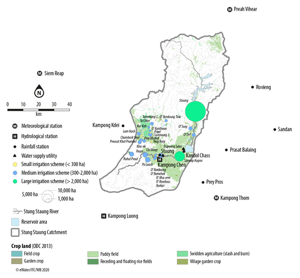
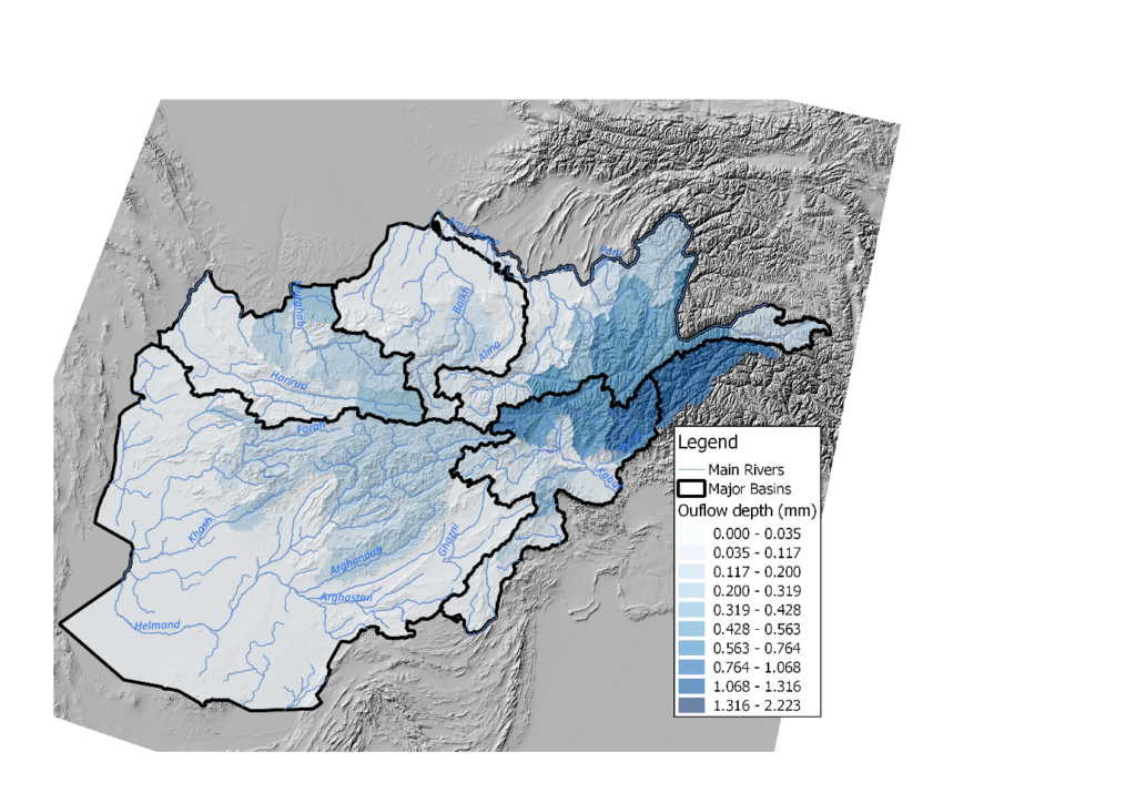
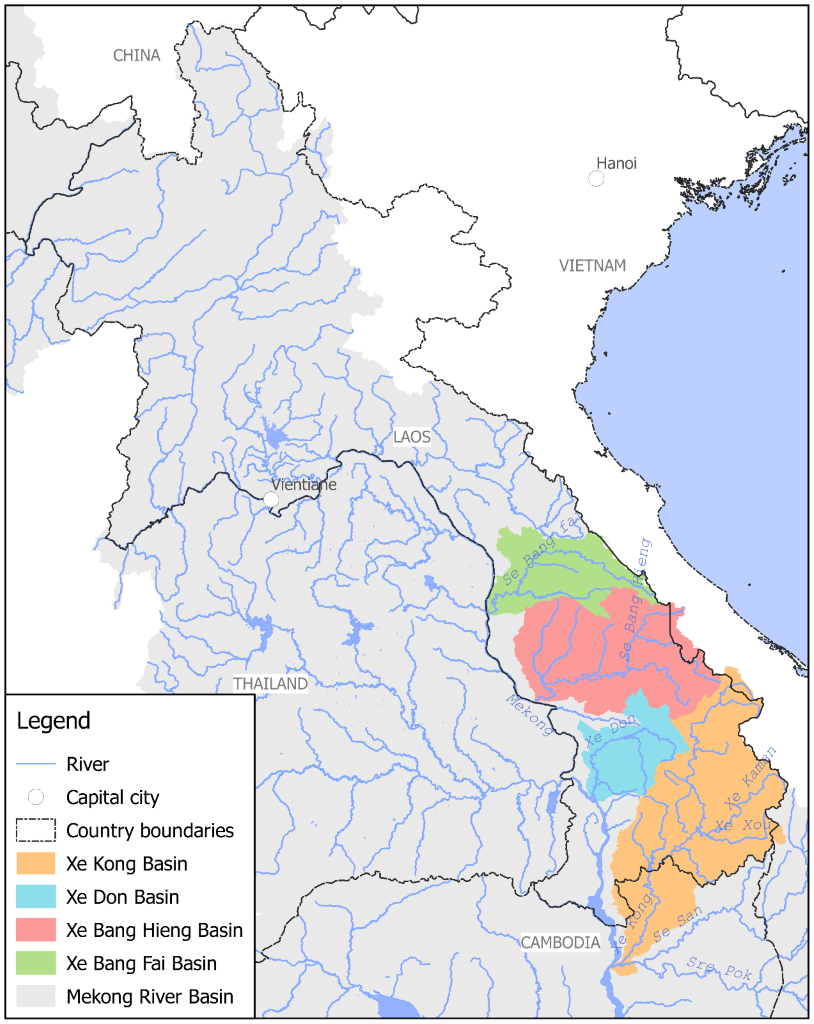
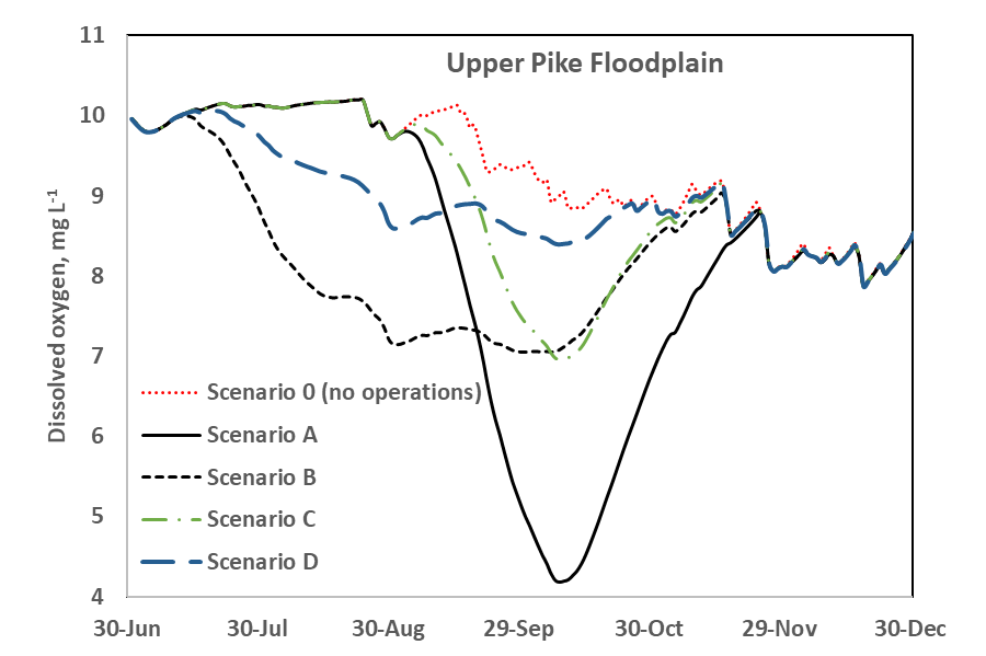
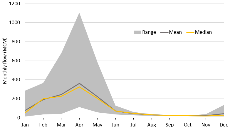
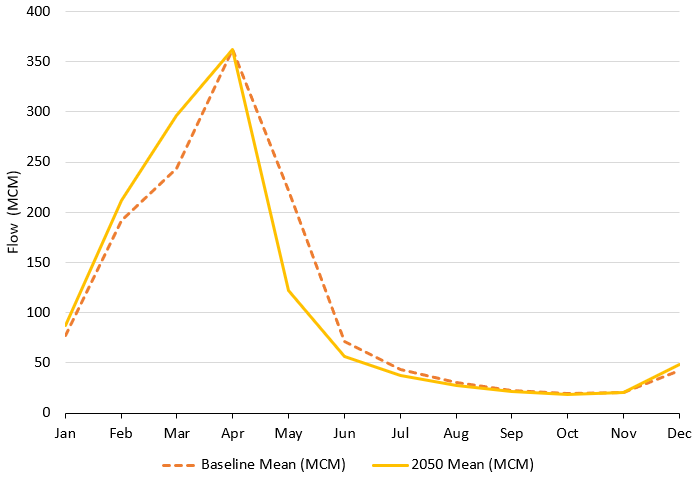
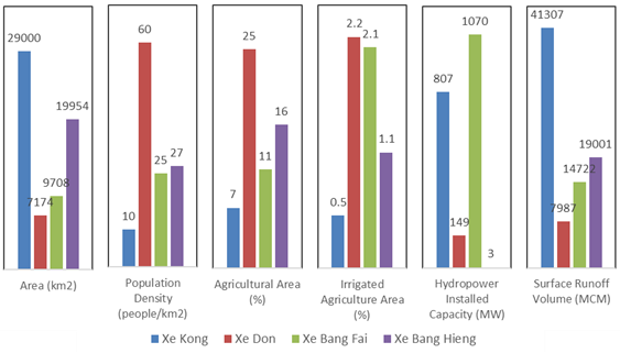
Summary of basin characteristics.
NB: For Xe Bang Fai the installed capacity represents the NamTheun 2 hydropower project, which is located outside of the basin and diverts water into the basin.
Summary of average annual water demands and the deficit in supply (represented as negative values) for the four basins.

Capacity building 

Building the capability of the NRERI Hydrological Modelling team was a core focus of the project. eWater provided tailored Source training and worked closely with the team in building the four models and developing the scenarios to be tested.

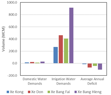
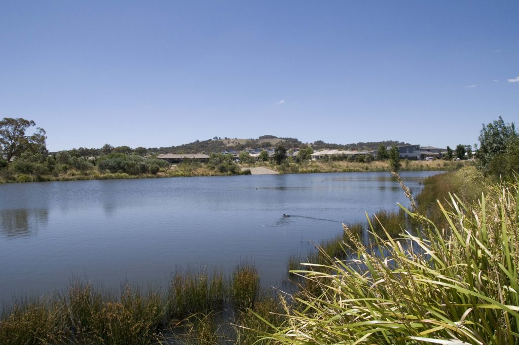
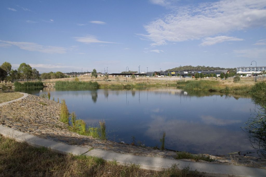
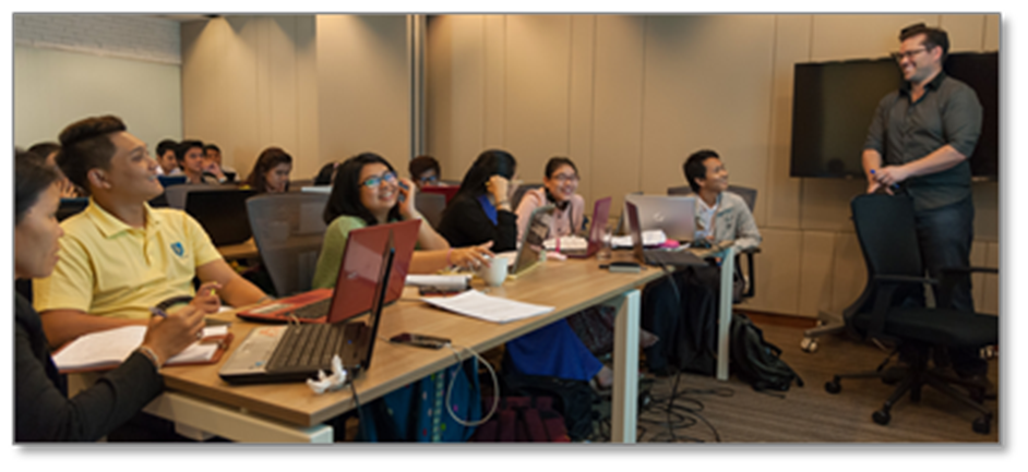
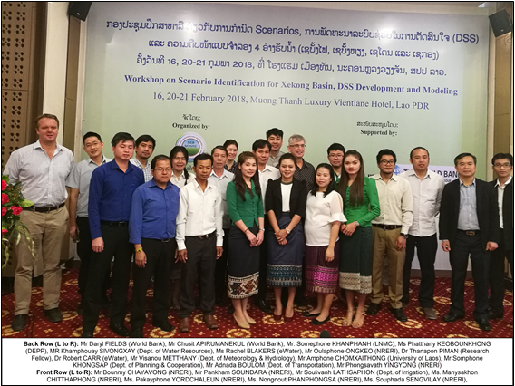
Participants at a workshop to develop scenarios for the Xe Kong basin. Attendees were from NRERI, other Lao PDR government agencies, the World Bank and eWater


Customising Source to manage blackwater risks

Construction of dams, weirs and use of water for irrigation, industry and towns has meant that many aquatic and floodplain ecosystems don’t get the water they did naturally.

One way of addressing this is to construct infrastructure, such as regulators and embankments that allow water managers to simulate natural watering regimes with lower flows.

While inundation brings a range of ecological benefits, it also has the potential to cause hypoxic blackwater (low dissolved oxygen) events. Blackwater events occur when inundation washes organic material from the floodplains into waterways leading to a rise in dissolved organic carbon in the water. This causes the water to turn a dark colour. The increased bacterial activity breaking down the carbon consumes oxygen, which causes a drop in levels of dissolved oxygen. In some circumstances, levels can drop so much that fish and other aquatic organisms do not have enough oxygen and die.

Blackwater can also create challenges for downstream water use, such as increasing treatment costs for drinking water supplies.

Blackwater events are a natural feature of many river systems. However, when natural flood patterns are changed and there are longer periods between overbank flows, the amount of organic material can be substantially increased, exacerbating the risk.

Changes to the natural inundation patterns of floodplains can increase the risk of blackwater events.

The project

As part of the South Australian Riverland Floodplain Integrated Infrastructure Program (SARFIIP), the South Australian and Commonwealth governments have invested in major infrastructure upgrades to provide water to the Pike and Katarapko floodplains. The infrastructure allows the Department for the Environment and Water (DEW) to create higher water levels to inundate the wetlands, improving watering frequency and the ecological health of the floodplains.The project includes a number of initiatives to manage potential blackwater risks. This has included developing a model to help understand and predict dissolved oxygen responses to different inundation events, giving DEW important information to design watering events with reduced risk of blackwater events occurring.

Spreadsheet models were previously used to help understand blackwater risks (Howitt et al. 2007, Whitworth and Baldwin 2016, known as the Blackwater Risk Assessment Tool – BRAT). While effective for non-complex situations, DEW was unable to represent realistic hydrology, such as events where water flowed into and out of different floodplains along the river. A more sophisticated approach was required. DEW determined the best approach to be to develop a Source plugin to model blackwater processes on the floodplains.

DEW and the Murray-Darling Basin Authority use the Source modelling framework to help manage the River Murray System. The Source framework uses “plugins” as a flexible way to build additional modelling capability into model. Combined with the South Australian Source Murray Model, the new Blackwater plugin allows DEW to model interactions between the river and floodplains and the different processes that contribute to the risk of blackwater events.

The approach

Conceptually, the model is based on the original spreadsheet models and represents the key influences on the generation of blackwater events (from SMEC 2015):

  • time period since the last inundation
  • the duration and rate of inundation
  • water exchange during inundation
  • temperature
  • area of inundation
  • litter loading
  • depth of inundation
  • influence of floodplain creeks on dilution
  • river dilution flows and proximity to environmental values

In addition, the model includes location specific information such as elevation, floodplain area and litter accumulation (from vegetation type), to understand the extent of inundation and litter accumulation.

The blackwater plugin is set up to represent all of the River Murray in South Australia, to consider interactions between the river and floodplains, as well as cumulative effects from multiple operations being inundated at the same time.

Conceptual model of the processes represented in the Source Blackwater plugin

Model performance

Model performance was tested in two ways. Firstly, simple floodplain scenarios were run through the Blackwater Risk Assessment Tool (BRAT) and the plugin. The results were comparable.

Secondly, a natural high flow event that inundated the Pike Floodplain in late 2016/early 2017 provided an opportunity to compare the model performance against observed DO data. The model compared well with the measured DO trends and magnitude but further testing under a wider range of scenarios is required to fully test the model. Notably, the event shows the importance of interactions with the river during blackwater events, as the majority of the DO decrease on the floodplain during Oct-Nov 2016 appears to relate to the low DO in the inflow water.

Modelled versus measured (at station A4260644, Pike River at Lettons downstream Rumpagunya Creek) dissolved Oxygen levels during the 2016-17 inundation event
Modelled versus measures (Station A42602644, Pike River at Lettons downstream Rumpagunyah Creek) Dissolved Oxygen levels on the Pike Floodplain during the 2016-17 inundation event.

Implementation

The model supports DEW to:

  • understand the potential DO changes associated with different environmental watering actions on the floodplains
  • adjust proposed watering actions to reduce the risk of blackwater events
  • forecast potential DO changes and blackwater risks from floods, and to identify potential river operations to minimise forecast blackwater events.

The figures below are two examples of the blackwater plugins outputs. The first shows the range of floodplain inundation under five different scenarios. The second shows forecast dissolved oxygen levels for each of the scenarios.

Hypothetical scenarios of water level upstream of environmental regulators to create floodplain inundation

Scenario A represents a fast fill of the floodplain to full inundation extent, potentially resulting in DO concentrations that could be detrimental to aquatic biota. Through the use of the DODOC plugin, operations can be designed to reduce these impacts.

Project partners

This work forms part of the $155 million South Australian Riverland Floodplains Integrated Infrastructure Program (SARFIIP) to improve the health and resilience of Riverland floodplains. SARFIIP is funded by the Australian Government through the Murray–Darling Basin Authority and implemented by DEW in partnership with SA Water.

The Blackwater Plugin was developed for DEW by the University of Adelaide and Flow Matters Pty Ltd. eWater was engaged by DEW to further develop functionality and modify the plugin to better work with improvements made to the Source platform after the plugin was developed.

References

Howitt JA, Baldwin DS, Rees GN and Williams JL (2007). Modelling blackwater: predicting water quality during flooding of lowland river forests. Ecological Modelling 203 (3–4):229–242. doi:10.1016/j.ecolmodel.20

SMEC (2015). SARFIIP Blackwater Risk Assessment: Stage 1. Report to the Department of Environment, Water and Natural Resources. SMEC, Adelaide in association with Natural Logic (Karla Billington) and University of Adelaide (Luke Mosley)

Whitworth KL, Baldwin DS (2016). Improving our capacity to manage hypoxic blackwater in lowland rivers: the Blackwater Risk Assessment Tool. Ecological Modelling 320, 292–298. 06.11.017

Acknowledgements

This case study was prepared in collaboration with the SA Department for Environment and Water and Murray-Darling Basin Authority.


Arghandab Integrated Water Resource Management Project – Afghanistan

Decades of war and political instability have decimated most of Afghanistan’s water infrastructure and reduced the technical capacity of the water resources sector. 

In response, the Government of the Islamic Republic of Afghanistan is undertaking a range of initiatives to invest in new infrastructure,  improve water resource management and increase capability. One such initiative is the Arghandab Integrated Water Resource Management Project. 

The Asian Development Bank (ADB) is supporting the Afghanistan Government to scope the Arghandab Integrated Water Resource Management Project. The project will finance infrastructure to increase water resources for irrigated agriculture, urban water supply, and power generation for Afghanistan’s second largest city Kandahar and surrounding areas.

Farmland in Kandahar (credit Paul/AdobeStock)

Using Source to support infrastructure investment

eWater was invited to provide technical assistance to the project, through a rapid hydrologic study of the Arghandab River and capacity building through training in the use of the Source modelling platform. eWater’s involvement was funded by the Australian Department of Foreign Affairs and Trade (DFAT). 

eWater, in collaboration with modellers in Afghanistan built a baseline Source model for the Arghandab River Basin. The model is used to generate inflows to Dahla Dam for the period 2002 to 2016. 

The model allows different multi-sector allocation scenarios for irrigation, urban water supply, hydropower and downstream flows to be compared against each other, providing key inputs to support the decision-making process. The potential impacts of climate change on the different options is considered by modelling different inflow scenarios. 

Overcoming data constraints

Water models typically rely on observed measurements for flow, rainfall, evaporation etc. However, such data is very limited in Afghanistan.  A combination of data from historic sources and remotely sensed sources were evaluated and used to develop the Source model. The hydrology is simulated using the GR4J and GR4JSG hydrological models which, respectively, represent direct rainfall-runoff and snow melt processes. The hydrology is calibrated to historic average monthly observed values.

Given that this is a rapid study where limited time is available to explore alternate sources of data such as some of the globally generated flow sequences used for detailed climate change modelling, an expedient approach to calibrating the model was adopted.  This was to assume stationarity in average monthly flows and calibrate to observed monthly average discharge values despite differences in dates between rainfall and discharge. This averaging impacts on the predictive ability of the model for extreme events such as flash flooding associated with sudden high rainfall since extreme peaks in flows can happen at a sub-monthly scale. 

Nonetheless, the model significantly increases the information available to water managers to understand current flows and support initial investigations into the impact of changes in dam size and demand over time and with climate change. Examples of the model outputs are shown below. 

Monthly flows

Flows are highly variable, particularly during the wet season. Monthly flows are lowest in October and November, and highest in April. The figure below shows the possible range in total monthly flows predicted by the Source model, with the grey area representing modelled minimum and maximum flows for each month. The modelled period 2002 – 2016 includes the drought years of 2010  2016 as well as extreme flows observed in 2007. Mean and median flows are also indicated.

Shows the total modelled monthly inflows to the Dahla Reservoir (2002 – 2016). Flows start increasing in December, peaking in April. Flows start falling through June and July, with virtually no flow from August to November.
Range in total modelled monthly inflows to the Dahla Reservoir (2002 – 2016)

Impact of climate change on flows

The projected impact of changes in temperature and rainfall on average total monthly inflows to Dahla Dam, between the baseline period (2002 – 2016) and future 2050 are illustrated in Figure X. Expected higher temperatures will cause snow to melt sooner in the season with an increase in flow in March and less water available from May resulting in a longer low flow season.

Average total monthly flow volumes (Baseline 2002 – 2016 and 2050)


Using Source for water and catchment management in the Australian Capital Territory

Source models support strategic planning, policy development, catchment and water resource management in the Australian Capital Territory

The models underpin the Australian Capital Territory (ACT) Water Strategy 2014-44 – Striking the Balance and support the ACT Government to meet its obligations under the Murray-Darling Basin Plan 2012.

Together with eWater, the ACT Environment, Planning and Sustainable Development Directorate (the Directorate) have embarked on a series of initiatives to upgrade the ACT’s Source models.

Improving water quality through wetlands like this is one in the Canberra suburb of Bonner is a central part of the ACT Water Strategy
(credit: Danswell Starrs, ACT Environment, Planning and Sustainable Development Directorate)

Audit of water models

The Directorate use several different Source models to inform strategic planning and decision-making regarding land use planning, urban development and climate change on water quantity and quality and the operation and maintenance of water infrastructure.

eWater was engaged to audit the Directorate’s existing Source models to ensure they were fit-for-purpose and could address emerging needs, including the ability to:

  • explore different policy, planning and management actions and assess potential impacts on the natural environment and water resources
  • predict impacts of land development decisions on water resources and assess mitigate measures 
  • test new ways of operating water infrastructure 
  • predict future environmental states to inform policy and management decisions, such as environmental condition and future water supply/catchment yields.

The audit identified several issues with the existing models that limited their ability to meet the current and future needs of the ACT Government. eWater recommended a substantial rebuild of the models, including:

  • Consolidating the existing nine models.
  • Utilising human-readable input sets and data sets to run scenarios, rather than individual models.  
  • Reconfiguring storages and lakes in the catchment model to better represent how they operate.  
  • Reconceptualising and recalibrating the rainfall-runoff models. 
  • Incorporating the ACT water supply system. 
  • Establishing a current conditions baseline case for scenario assessment. 
  • Preparing and justifying a baseline scenario for the comparison of land use change scenarios. 

Model rebuild

Following on from the audit, eWater was engaged to rebuild the ACT’s catchment and planning models.

eWater built two new Source models for the ACT, a catchment and a planning model.  Model performance has been improved by reducing the number of sub-catchments outside of the ACT. The new models use LASCAM (Large-Scale Catchment Model) rainfall-runoff models, allowing for physically based assessments of hydrological impacts of land use change. The catchment model now incorporates Canberra’s water supply system, including storages. The consolidation of the models allows for different policy and management options to be implemented by Scenario Input Sets.

In addition to the model re-build, the project also included collaborating with the ACT Office of the Chief Digital Officer to the integrate Source models with the ACT Government Water Data Management System. This brings two main benefits, it streamlines the transfer of data and model outputs and adds dashboarding capabilities to improve the presentation of model outputs. Integrations was achieved through a customised plug-in, developed by the eWater Software Development Team.

eWater also provided customised training to Directorate staff, to ensure they understood the Source model and were able to support its future development and application.

The updated models will support the ACT Government to better manage urban stormwater and flooding risks
(credit: Danswell Starrs, ACT Environment, Planning and Sustainable Development Directorate)

Implementation

The Directorate is using the models to inform a wide range of water and catchment management activities, including to:

  • support investment in catchment remediation and
    investment, by helping identify which areas will lead to the greatest
    improvements in water quality and/or water yield
  • investigate Integrated Catchment Management
    options across the ACT and the greater region
  • understand stormwater and flooding risks in
    urban areas
  • forecast future water supply and demand
    scenarios
  • compare likely outcomes from different water
    efficiency initiatives
  • investigate alternative water supply options,
    such as treated effluent, grey water and stormwater for consumptive and
    non-consumptive uses
  • test different options to improve the management
    of rivers and lakes, to promote recreational use and reduce risks to public
    health.

Acknowledgements

This case study was prepared in collaboration with the ACT Environment, Planning and Sustainable Development Directorate.


River Basin Models and Water Sharing Policy in the upper Godavari Sub-Basin, Maharashtra, India

Resolving tension between farmers upstream and downstream over water allocations in the upper Godavari River in Maharashtra was the focus of a four year engagement in the west Indian State by eWater.

The Maharashtra and New South Wales governments signed a Memorandum of Understanding for cooperation across a wide range of issues.  Under the provisions of this MOU, the Government of Maharashtra in partnership with the NSW Department of Industry, Lands and Water (then) engaged eWater to provide training, technology transfer, and ongoing support in the use of Australian river modelling technology to Maharashtra.

eWater assisted the Maharashtra Department of Water Resources to develop a modelling framework to test water management options and to support the development of an integrated water resources management (IWRM) plan for the Upper Godavari sub-basin.

Basin overview

The Godavari River basin is India’s second largest river basin, it covers 50% of the land area of Maharashtra state.  It is a complex system, with 20 dams. Water use includes irrigated crops, industry and domestic use in urban and rural areas, including drinking water.  Water availability and equitable distribution of water within the sub-basin are major public concerns that have resulted in legal challenges.

Within the sub-basin there is significant spatial and inter-annual variability in monsoon rainfall. Typically, runoff is generated in the high-rainfall, high-elevation areas of the sub-basin with little runoff generation in the area near the large Paithan irrigation dam at the outlet of the Upper Godavari. 

Paithan Dam, after upstream monsoon rains.

Project outcomes

The project had two primary outputs, a calibrated Source model for the Upper Godavari Sub-Basin and building the capacity of the Maharashtra Department of Water Resources.

eWater, in collaboration with modellers from the Maharashtra Department of Water Resources set-up and calibrated a Source model for the Upper Godavari sub-basin. The model was used to evaluate water management options to improve equitable access to water across the sub-basin. Model outputs were used to inform the integrated water resource management plan

eWater and the NSW Department of Industry, Lands and Water used outputs from the river basin models to establish and focus communication and discussion with the Maharashtra Water Resources Department about improved water management policies and governance processes to implement the objectives of the Maharashtra State Water Policy. With a key focus being improving targeted communications to farmers in the basin.

eWater delivered a comprehensive training program in the use of Source, with customised training based on the Upper Godavari model. Training was held in India and Australia, both involved a combination of hands-on desktop learning and field visits to better understand the linkages between models and on-ground water management. 

More broadly, the project brought together water managers, academics and researchers in the Upper Godavari sub-basin to establish a community of practice that allows lessons and experiences to be shared across other sub-basins in Maharashtra.

Delegates learning about modern irrigation technology in the Murray-Darling Basin.

Award winning project

The success of the project was recognized at India Water Week 2019, when the national Minister for Jal Shakti (Water Resources) presented an award to the Maharashtra Water Resources Department (WRD) for using eWater Source modelling framework to achieve equitable distribution of water in the Upper Godavari Sub-basin.

Left to right: Mr Arun Ghate (IWRM team GMIDC), Mr Jasing Hire (IWRM team GMIDC), Mr Ajay Kohirkar (Executive Director GMIDC), Mr Dilip Tawar (Chief Engineer GMIDC), Mr Rajendra Pawar (Secretary Command Area Development, WRD), Ms. Sonali Nagargoje (IWRM team GMIDC), Mr. Avirat Chavan (IWRM team GMIDC)


Melbourne Water – Improving water security with Integrated Water Resource Management

For 130 years Melbourne’s catchments and water infrastructure have provided for the water needs of Melbourne’s growing population and industry.

Population growth and climate change are putting increasing pressure on Melbourne’s traditional water supplies. Melbourne Water is working with retail water company customers to adopt a more integrated approach to delivering water services, with the aim of a city that is water sensitive, sustainable and liveable.

By adopting an Integrated Water Resource Management (IWRM) approach, Melbourne’s water companies are investing in a range of present or future innovative water management options, at the household, street, and suburb development scale, including:

  • recycling and reusing wastewater for things like agriculture, firefighting and dual-pipe systems that provide recycled water to homes and businesses for non-potable use like toilet flushing and watering gardens
  • recycling wastewater on site
  • capturing more stormwater for watering parks and sporting fields
  • refilling groundwater aquifers with stormwater or recycled water, for later extraction and use or to support natural environments

The IWRM approach requires a complete rethinking of the analysis of water system management. Traditional water system models are limited in their ability to analyse IWRM. Recognising this, Melbourne Water, with the support of eWater, has undertaken significant work to modernise their water resource models and to develop new tools to assess the benefits of IWRM.

Melbourne Water is increasing its use of recycled water

A new approach to water resource modelling

Work has focused on three key areas:

  • upgrading the bulk water supply infrastructure (headworks) model
  • integration with local water supply and demand models
  • new tools for improving model performance.

Source Headworks Model

For the past 25 years, Melbourne Water has used the REALM (REsource ALlocation Model) Headworks System Simulation Model. The REALM model runs on a monthly time step and is used mostly for long-term water planning. Traditional monthly timestep water resource models like REALM focus on the behaviour of the centralized bulk water supply system and have limited ability to address emerging modelling needs, such as:

Maroondah Reservoir
Melbourne Water is reducing its
reliance on traditional water supplies.
  • To what extent can small scale alternative water sources, such as greywater, recycled water or stormwater, be utilized?
  • What is the best mix of centralized and decentralized supply options?
  • How will water use change with different policy options or new approaches?
  • Where are the best locations for, or uses of decentralized systems?
  • How to leave more water for healthy river flows and reduce stormwater pollution ?

Working with eWater, Melbourne Water is in the process of replacing the REALM model with a Source model. The new model can run on both a monthly and a daily time step and includes headworks infrastructure and water supply catchments. Catchments have been added to give a better assessment of both the amount of water flowing into the reservoirs and the quality of that water. This will be important for understanding the impacts of changes in the catchment, for example after bushfires or how climate change might impact runoff and streamflows.

The monthly time step mode has been kept to support long-term water management decisions, with important improvements, including customised water allocation rules to determine allocations for primary entitlement holders, such as the water retailers and new optimization tools help assess operating strategies, to find the optimal trade-offs for different management objectives, such as cost and security of supply.

The daily time step mode supports Melbourne Water to manage environmental water in the regulated streams and to meet streamflow requirements in unregulated streams. It also facilitates smaller scale IWRM modelling and helps to better understand the potential risks to water quality. Importantly, the model has been designed to easily switch from a monthly and daily time step, allowing for better integration between short, medium and long-term operating plans.

Headworks models are designed to find the best way to meet water demands and inform the reliability of water supply. As such the representation of demands in the model is equally as important as the representation of water supplies. An innovative feature of the new model is the incorporation of spatial geographic data to better understand demand. Spatial data includes population data, dwelling types and land-use. Ultimately, it will help estimate changing water demand and the potential impact of alternate water supplies at the suburb scale.

Urban Developer in Source

The upgrades to the headworks model bring a wealth of new features to support IWRM but they do not fully take into account potential alternative water supplies, such as rainwater, stormwater and wastewater, or localized demands. A second component of the project has been to incorporate eWater’s Urban Developer tools into the Source platform. This allows local small scale water sources and demands to be considered in the context of overall large scale supply options.

Urban Developer can now estimate urban water demands based on a suburb’s characteristics and how they might change, for example with population growth, dwelling type, the adoption of Water Sensitive Urban Design approaches or alternative water supplies like rainwater tanks. The approach was tested across four catchments and the model calibrated for the Melbourne region. The Urban Developer plugin to Source was developed to feed the outputs of the Urban Developer demand model into the Source Headworks Model.

An important aspect of the work was looking for more sophisticated ways to estimate demand and to differentiate between indoor/outdoor water use, and commercial and industrial water use. For example, we can now test if including information on household income or lot size provides more accurate water use estimates.

The Source Urban Developer plugin allows detailed analysis of urban water use

Improving model performance

Running large, complex models for different scenarios takes a lot of computing power and time. Melbourne Water uses optimization tools to inform water resource decisions by assessing how to maximise the reliability of supply and reduce delivery costs. With the enhanced model functionality, it would take a month to process Melbourne Water’s optmisation runs on a standard computer, even longer if new requirements, such as environmental flow delivery and integrated demand management options were included.

Working with eWater, a cloud-based run manager was set up to enable large numbers of simulations to be run across hundreds of virtual machines. A common web browser interface gives access to different run locations, including a local (single PC) and the Cloud (hundreds of virtual machines). Run times have been reduced to a number of hours.

In addition to saving time, the system is easy to install and use, does not require specialist knowledge and reduces the costs associated with owning and maintaining significant amounts of hardware. A particular advantage is that jobs can be tested locally before launching on the cloud, reducing the risk of minor errors negating the final results and the modellers can continue working on other projects while the simulation is being run.

Following the initial success, work is underway to expand the type of jobs that can be run on the cloud and to make Source and the optimisation tool, Insight, more cloud friendly.

Conclusions

The project has delivered significant improvements to Melbourne Water’s modelling tools. Innovative projects like these require flexibility, new ways of thinking and a high degree of collaboration. eWater and Melbourne Water have worked closely together throughout the process, proposing and testing different methods, refining and adapting along the way. A key aspect was including Melbourne Water in the software development process and allowing them to work directly with eWater to scope and prioritise software improvements.


Using Australian water tools to develop new drought metrics for Cambodia

eWater, Geoscience Australia (GA) and the Australian Bureau of Meteorology (BOM) collaborated to pilot using space-based data to forecast streamflows and water availability.

With the support of the Australian Water Partnership, eWater, GA and the BOM worked with the United Nations Economic and Social Commission for the Asia Pacific (UNESCAP) to develop new metric’s for the their ‘Regional Cooperative Mechanism for Drought Monitoring and Early Warning in Asia and the Pacific’ (the Regional Drought Mechanism)

The project integrated three leading Australian tools for water management:

  • Australia’s National Hydrology Modelling Platform – eWater Source
  • GA’s Open Data Cube for accessing and managing space-based data
  • the BOM’s streamflow forecasting tools

The pilot project integrated the three tools, to develop streamflow and water availability forecasts from space-based data. Traditionally, such information requires significant on-ground data and complex analysis tools. The pilot highlights the potential of the integrated suite of tools to significantly increase the information available to water and agricultural managers and farmers to anticipate and plan for drought conditions.

Further, the use of Open Data Cube technology enabled many Source model inputs to be generated automatically, reducing the time to build the model, potentially making modelling more accessible to water managers.

The information was made available in a relatively simple format and accessed through mobile technology via https://escap.ewater.org.au/

Read more

As this image shows, water levels in Cambodia are highlighly variable. Metrics such as those produced in the pilot provide more information to help Cambodian water managers and users adapt. (credit: simoscalise/ Adobe Stock)