How Source supports the management of the Murray-Darling Basin
The Murray–Darling Basin is the largest and most complex river system in Australia. It runs through four States and one Territory and has a river network of 77,000 kilometres.
The Basin is home to more than 2.6 million people and has significant economic, cultural, social, and environmental values. Agriculture in the basin produces $24 billion annually, its waterways provide clean drinking water to 3 million people and its unique environment is home to 120 species of waterbirds and 46 species of native fish.
Modelling plays an important role in supporting the management of the Murray-Darling Basin. The need for a modelling platform that could be used across the basin’s diverse river systems was a key driver behind the National Hydrology Modelling Strategy. This case study highlights some of the ways Source models are used by the Murray-Darling Basin Authority (MDBA).
Water resource planning
The MDBA, in partnership with the River Murray States, have built a Source model to support water resource planning in the River Murray and lower Darling river systems. The Source Murray Model (SMM) is based on a daily timestep and includes:
- system inflows
- flow routing and losses
- irrigation, stock and domestic, town water supply and environmental demands
- inter-state water sharing, allocation and ownership
- definition of State Water access rights, allocation and accounting
- water trade
- water ordering and the operation of dams and infrastructure
- salt transport.

The SMM allows the MDBA and Basin States to test policy and management options and observe the likely impacts changes may have on the system, such as possible changes to State water shares or the reliability of supply to water users, compliance with the Basin Plan or to manage river salinity levels. Options can be compared against four standard planning scenarios:
- Without Development – removes consumptive diversions and regulating infrastructure (dams, weirs, offtake regulators etc.) to estimate what might have happened without regulation
- Baseline Diversion Limit – represents the best estimate of conditions at June 2009, this scenario is used to define the Baseline conditions under the Murray-Darling Basin Plan (Basin Plan)
- Current Conditions – represents the best estimate of the current management and operation of the Murray and lower Darling rivers
- BSM2030 – represents the process used to calculate and maintain the salinity registers, which are central to the joint management of salinity in the River Murray system under the Basin Salinity Management 2030 strategy.
River operations
The MDBA is responsible for managing the River Murray and lower Darling rivers in accordance with a long-standing agreement between the Australian Government and the Basin states. As part of this, the MDBA implements water sharing arrangements, manages water infrastructure and delivers water to meet irrigation, stock and domestic, urban water supply and environmental demands.
To do this, the MDBA must understand:
- how much water is in the systems dams
- current and forecast river flows
- inflows from tributaries, including water trade
- how much water will be lost to evaporation and seepage
- demand for water along the length of the river system
- system constraints and operating rules
For many years the MDBA has used a spreadsheet model to support its river operations. Together with eWater, the MDBA has built a Source operations model to replace these spreadsheets. This source model is currently being tested before adoption. On completion of this testing, the model will give river operators a much more powerful management tool, allowing them to readily plan for operations under many different scenarios and to simulate the potential impacts of different operational decisions, on a daily and seasonal basis.

Environmental flow modelling
Over the last decade, significant volumes of water in the Murray-Darling Basin have been set aside for environmental purposes. Managing and delivering this water provides a range of new challenges for water managers.
The MDBA, Commonwealth Environmental Water Holder, then New South Wales Office of Environment and Heritage, Victorian Department of Environment, Lands, Water and Planning, and the South Australian Department for Environment and Water collaborated with eWater to better enhance environmental water modelling functionality in Source, through the:
- environmental flow node – defines environmental flow demands based on a range of criteria, such as frequency, duration or magnitude of flows or event triggers
- environmental water manager – to compare and prioritise different environmental demands, both spatially and temporally, subject to environmental water allocations.
This functionality allows river operators and environmental water managers to model different flow scenarios, to compare potential environmental benefits, understand the possible impacts on river operations and identify opportunities to boost environmental outcomes by combining with other water deliveries.
Managing salt
Large areas of the Basin are underlain by ancient marine sediments. Land clearing and water intensive farming has brought saline groundwater closer to the surface and into the river system. Increased water use has reduced river flows, resulting in less water to dilute the salt or flush it out to sea.
High salt levels can have serious implications for water quality, plant growth, land productivity, biodiversity, and the supply of water for human and animal needs. Managing the impacts of salinity is one of the most significant challenges in the Basin. Since the 1960s, governments and communities have worked to manage salt through improved land management practices and infrastructure. In 2015, the MDBA and Basin States launched the Basin Salinity Management 2030 strategy, which sets out how governments are working to address salinity and meet agreed targets.
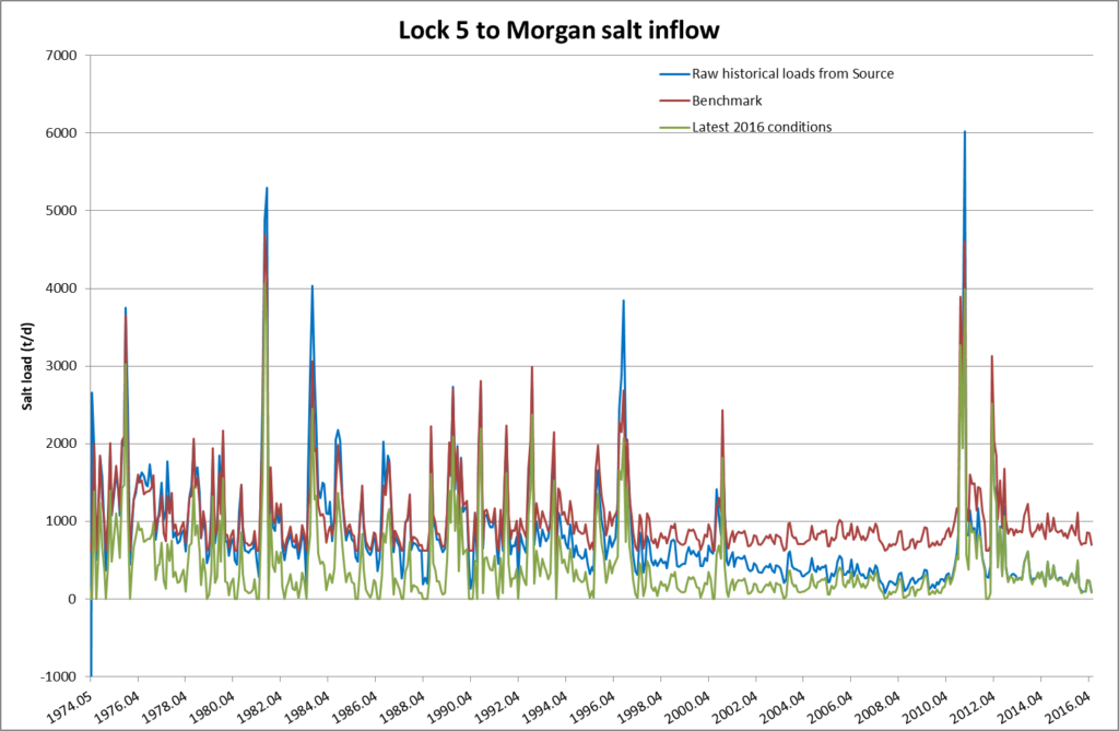
Modelling underpinned the development of the strategy and will be a key part of its implementation. The SMM was used to understand baseline flows and to set agreed salinity targets. The model can also be used to test different management actions and how these might affect salt loads and salinity, and achieving the aims of the strategy. Using the SSM, baseline salt loads can be determined and to assess how these might be affected by different flow regimes or management actions. Figure 2 provides an example of the model outputs, it compares historic, current and benchmark salt loads.

This case study was prepared in collaboration with the Murray-Darling Basin Authority
