From Our Chair: Australian Water Solutions

Australian Water Solutions and the role of eWater Group in Australia and internationally

Greg Claydon, Chair and Independent Director, eWater Limited Board, deep dives into the challenges ahead for the water industry next year and the role of eWater Group in Australia and internationally.
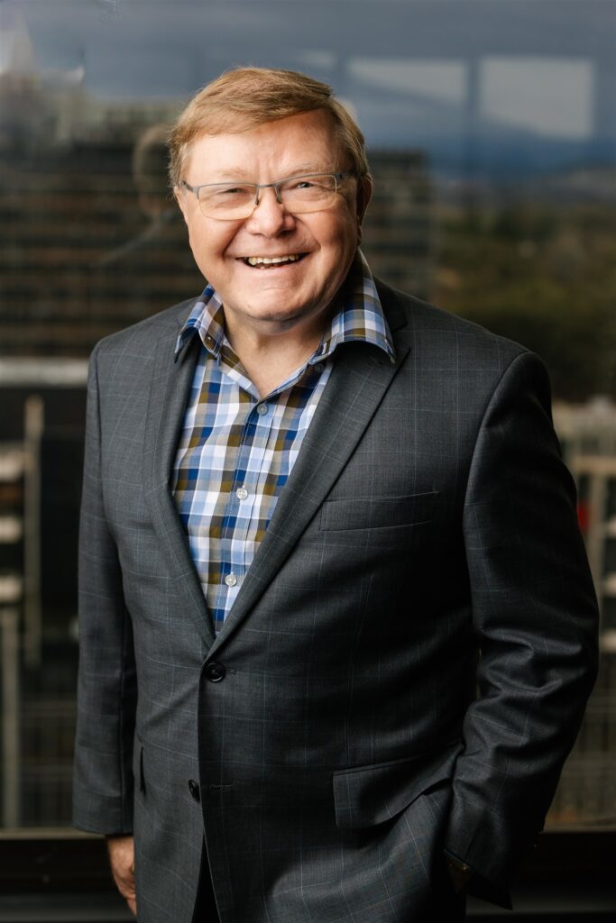
As we move into our twelfth year of operation as eWater Limited, this past year has provided an opportunity to refresh the strategic direction of the organisation, including strong custodianship of a modernised national hydrological modelling platform that is fit-for-purpose, now and into the future. 

No other organisation can ensure the safe custody and prudent ongoing development of this critical national asset.

eWater Source, used appropriately, greatly assists those tasked with the sensible and sustainable management of Australian water resources to make high-quality, informed, confident, transparent, equitable and wise decisions.

This past year was also an opportunity for the Australian Water Partnership and Mekong Water Solutions to further strengthen our international efforts and our partnerships to build water security, resilience, equality and understanding in the face of climate change, population growth, demographic shifts, poverty reduction and other challenges. 

Through these efforts and partnerships, we aim to support and further develop Australia’s world-class water management and modelling products, services, and capabilities.

We also aim to deliver operational excellence and capacity building as a trusted adviser to international governments, demonstrating and exhibiting strong capabilities in international development program management.

Most importantly, we finish 2023 in a stronger financial position than we started – this was no easy feat. It means we are going from strength to strength as we can continue our work in pursuit of better water management both in Australia and with our partners overseas and that is what eWater is all about.

This year, like many other water advocating organisations in Australia and around the world, we have seen some challenges, all of which we can address through strong cooperation, collaboration, and commitment.

For the wider water industry first, the all-encompassing challenge is how do we come to grips with our changing climate – preparing for and dealing with the increased variability, the bigger floods and the longer droughts, the higher temperatures and higher sea-levels, and less rainfall in many areas. That, combined with continued population growth and changing demographics, including expanding cities, puts tremendous pressure on water security for the environment, for industry and for communities. These all-impact people’s lives and livelihoods.

At the same time, there are imperatives to better manage available water supplies more efficiently and get the best outcomes from water for the environment, while recognising the importance of meeting cultural water provisions and the needs and aspirations of First Nations people in water management.

And concerns continue to grow about threats to water quality and the distressing impacts of poor water quality on people and the environment.

So, there is still a lot to do to have an efficient and sustainable water industry. It continues to be important to invest in science and knowledge, skills and capacity and decision-support tools, to exercise leadership and good governance and to support initiatives like a refreshed National Water Initiative and overseas aid programs that seek climate resilience, poverty reduction and equity of opportunity.

All the above actually present tremendous opportunities for eWater Group.

The challenge is to make those opportunities a continuing integral part of our business by way of partnerships, investments, commitments, and innovation.

That is why, for example, eWater Group is determined to modernise eWater Source as the National Hydrological Modelling Platform that is fit-for-purpose for 2030 and beyond. Not only is eWater Source a focus, but we are also looking to update the science underpinning the eWater MUSIC modelling platform, to further improve information and decisions about water sensitive urban design and improved water quality in urban settings.

That is also why eWater Group is keen to deliver phase 3 of the Australian Water Partnership, building on the tremendous achievements of the first two phases managed by eWater. And we also would like to continue our great work in the Mekong, including with the Mekong River Commission, which has been a valuable partnership over many years.

I think it is fair to say that we all desire greater certainty in these uncertain times. eWater Group can provide the strategies, the skills, and the tools to help with that.
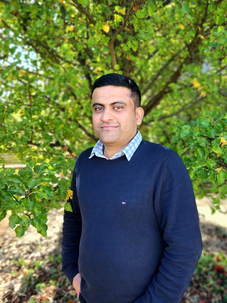
Meet Sudeep Nair, Hydrologist

We are continuing the Meet Our People series where we put the spotlight on the people that make up eWater Group. We are an organisation focused on delivering smart, sustainable water management solutions in Australia and internationally.

Sudeep Nair is one of our hydrological experts who has been working within our organisation and supporting our partners and clients nationally, and internationally, for nearly two years now, in addition to his 10 years of experience in the field of water resources management and modelling.

Sudeep’s interest in water resources began when he started his postgraduate studies at IIT Kharagpur leading him to pursue his doctoral studies in Environmental Hydrology and Water Resources, and eventually academia. But the urge to work on real-world water resource problems and water modelling was too great, and Sudeep made the leap from research to eWater Group.

As one of our hydrologists, Sudeep works on Australia’s National Hydrological Modelling Platform, eWater Source, and MUSIC, and supports this country’s most prominent government and non-government organisations to find solutions to support sustainable water management.

“I get the opportunity to involve in both the development of the tools and their application to solve real-world water management problems. Moreover, I am part of the team which supports the adoption and use of our software products through various training programs.”

Acting as a bridge between our customers, who include hydrologists and water modellers, and the software developer team, Sudeep identifies, tests, and reviews their models to ensure there are working at optimum levels to deliver high-quality water data and information in real time.

“I don’t have a typical day [at eWater Group] which is why I like working at our organisation. The hydrology team is a small and cohesive team, and we get the opportunity to get involved in almost all activities such as the development of new functionalities in Source and MUSIC, software maintenance and support, modelling, supporting clients and partners, and training.”

While our hydrology team may be small, it has a huge impact. “As a key member in a small team, my suggestions and feedback are heard and valued. It feels like a family here in eWater. I am also given the opportunity to undertake various training to regularly update my skills and knowledge.”

Like any industry, we face many challenges in water management and delivering high-quality data and information to a growing audience in Australia and internationally. For eWater Group our focus is offering Australian governments, water experts and institutions here and abroad the highest of expertise, knowledge, and support.

For Sudeep, the challenge we face is the need for clarity amongst modellers regarding the selection of appropriate water modelling tool to address changing and emerging needs of water managers.

“eWater Source [the National Hydrological Modelling Platform] is different and is increasingly being adopted in Australia which enables uniformity and comparison, along with [our other modelling platform] MUSIC, which is already used widely in Australia for urban water modelling purposes.

eWater Source, and MUSIC, are constantly evolving tools, with more capabilities and functionalities added to our toolkit based on customer feedback and requests. It is this continued drive to deliver better support and services which “make eWater tools ready for assessing new water-related challenges in the wake of climate change and other pressures.”

Who are we?

eWater Group is owned by the Australian Federal, State and Territory governments to further develop Australia’s world-class modelling tools and to provide support and training nationwide and internationally.

Our organisation is comprised of three divisions – eWater Solutions, the Australian Water Partnership and the Mekong Water Solutions to deliver water management solutions for communities in Australia and overseas.

We also partner with the Australian Department of Foreign Affairs and Trade, and research groups and institutions to provide expertise and support for sustainable water management solutions in Australia and internationally, now and into the future.


Supporting Queensland’s next generation of water modellers

The Queensland Water Modelling Network (QWMN) aims to improve the state’s capacity to model its surface water and groundwater resources and improve the quality of it’s models. 

Established by the Queensland Government in 2017, the QWMN provides tools, information and collaborative platforms to support best-practice use of water models and the uptake of their results by policy makers and natural resource managers. The QWMN encourages engagement between modellers, researchers, policy makers and resource managers.

A key focus of the QWMN is building Queensland water sector capability through its mentoring program. The program partners experienced modellers with university undergraduate students and young water professionals interested in water modelling, it The aims to:

  • Grow the size and capabilities of the Queensland water modelling workforce by building a pipeline of skilled and enthusiastic graduates who want to pursue water modelling careers in Queensland.
  • Expose students to ‘real world’ water policy issues so that they develop applied knowledge and become enthused about the work of water modellers.
  • Develop undergraduate student critical analysis and systemic understanding of how the outputs from water models are and can be used.

The program has two components. Firstly, students undertake online water model training and tutorials to become familiar with the relevant models and tools. Students then undertake a ‘real world’ modelling challenge, supported by mentors who are experienced Queensland Government modellers.  

eWater is an active supporter of the mentoring program, providing access to the full version of Source, training materials and technical support for participants.

Phase 1 of the program has been successfully completed by students from Griffith University, James Cook University, University of South Queensland, Queensland University of Technology and University of Queensland and a young professional within the Queensland Department of Natural Resources Mines and Energy (DNRME).

Students used eWater Source to understand how water quality targets are set for the Great Barrier Reef catchments. The Cattle Creek sub catchment within the Mackay/Whitsunday region used in the challenge. Through the project, participants both learn how to use Australia’s National Hydrological Modelling Platform, eWater Source and are exposed the the challenges faced by both government and industry to meet the Great Barrier Reef water quality targets.

The program has since been extended to students at the universities of Central Queensland and the Sunshine Coast in 2020-21. The QWMN is also working to engage modelling experts from the private sector.

More about the QWMN

More about eWater Source and managing the Great Barrier Reef


Paddock to Reef – Integrated Monitoring, Modelling and Reporting Program

Targeting investment to improve the health of the Great Barrier Reef.

What is the Paddock to Reef program?

The Paddock to Reef Integrated Monitoring, Modelling and Reporting Program (Paddock to Reef program) started in 2009 as a joint initiative of the Australian and Queensland governments to report on water quality improvement resulting from investment in improved land management practices. Improving the quality of water leaving properties by reducing pollutant run-off is critical to build the health and resilience of the Great Barrier Reef (GBR). The program brings together industry bodies, government agencies, natural resource management bodies, landholders and research organisations.

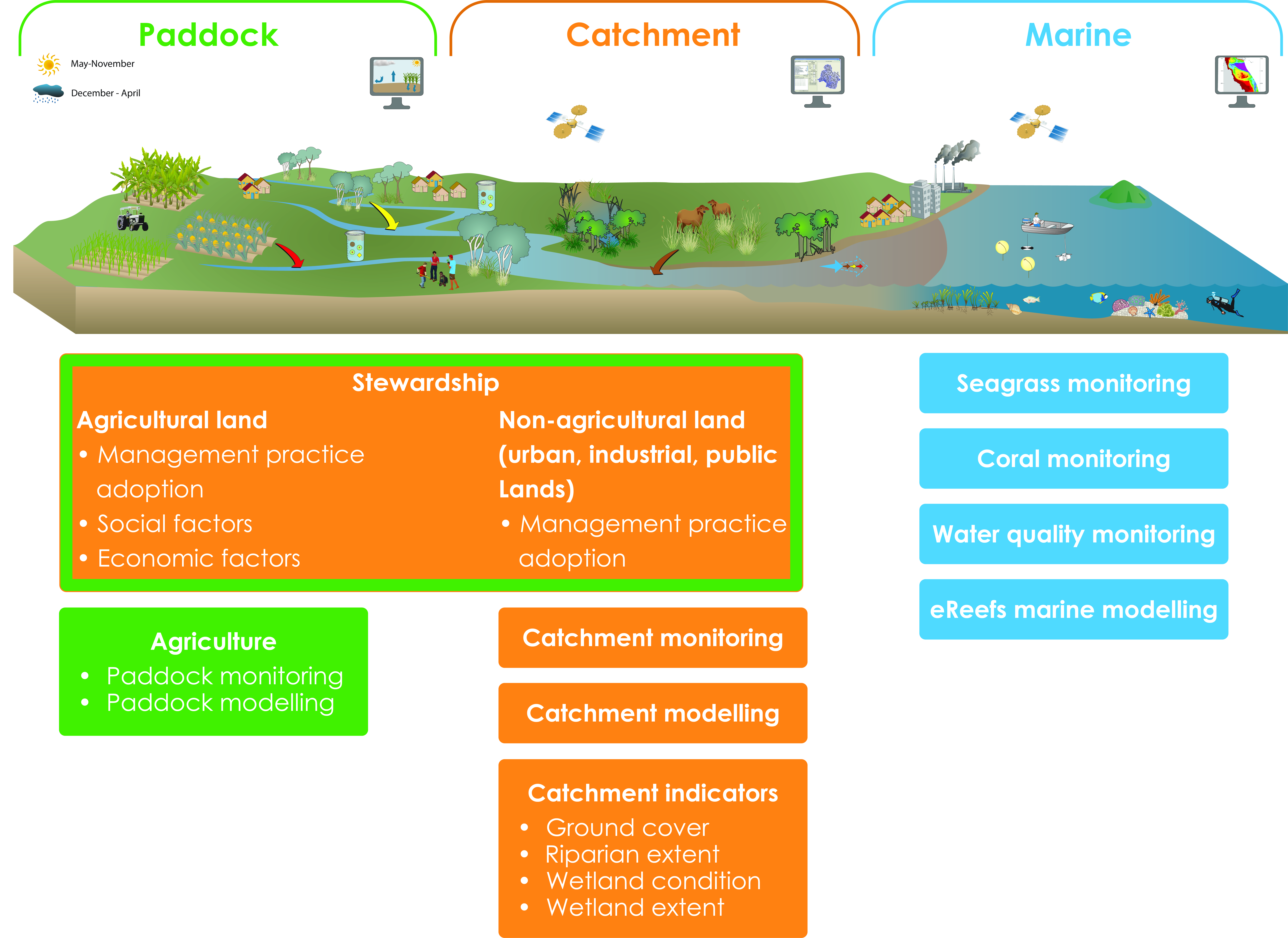
The program provides a framework for evaluating and reporting progress towards the Reef 2050 Water Quality Improvement Plan targets. It integrates monitoring and modelling information on management practices, catchment indicators, catchment loads and the health of the Reef at the paddock, sub-catchment, catchment, regional and whole GBR scales (image below). The program evaluates management practice adoption, management practice effectiveness (in terms of water quality benefits and economic outcomes), catchment condition, pollutant run-off and marine condition.

Focus areas for the Paddock to Reef program

How does Source support the program?

The catchment modelling for the program is based on the Source platform, with customised plug-ins developed by the Queensland Government to provide additional water quality functionality. A range of other purpose-built data collection and reporting tools have also been built to support the program. These include interactive maps to show pollutant generation rates and priority investment areas.

The models are primarily used to report on annual progress towards the reef water quality targets as a result of investment in improved land management practices. Model outputs are also used to determine priority areas for investment and to assess possible outcomes from different scenarios such as different rates of adoption of improved practices. The catchment models also provide inputs for the marine models.

The Paddock to the Reef program helps manage the impacts of landuse on the quality of water flowing to the Great Barrier Reef, Qld
(credit: WITTE-ART.com / Adobe Stock)

Information sharing

Many of the actions required to achieve the water quality targets need to be undertaken by farmers and other land managers. To support greater uptake of the required actions, the Paddock to Reef program has been designed to share technical information in a way that can be easily understood and used. It also incorporates the local knowledge of land managers. Program features include:

  • Multiple lines of evidence to inform progress towards the targets.
  • Technical experts are based in the regions, giving them a good understanding of the local environment, issues and the effectiveness of management actions. This also helps build relationships with local land managers.
  • Ongoing refinement of the models and other tools to incorporate new knowledge, data and methods.
  • Results are presented online through an interactive reporting system to cater for the broad range of stakeholders interested in the results from the general public to scientific experts.
  • Data is made available to support other programs, for example regional report cards and regional natural resource management body and local government investment decisions.
  • ‘Cut down’ models provide locally specific tools to assess individual projects and prioritise local investment.

Peer review, continual improvement and validation are critical elements for any modelling program. The Paddock to Reef catchment modelling program undertakes an external review every three years. The program is supported by a GBR-wide pollutant loads monitoring program which provides data to calibrate and validate the catchment models and increase confidence in the models over time.

For further information go to Reef 2050 Water Quality Improvement Plan website https://www.reefplan.qld.gov.au/tracking-progress

Acknowledgements

This case study was prepared in collaboration with the Queensland Department of Environment and Science.


Customising Source to manage blackwater risks

Construction of dams, weirs and use of water for irrigation, industry and towns has meant that many aquatic and floodplain ecosystems don’t get the water they did naturally.

One way of addressing this is to construct infrastructure, such as regulators and embankments that allow water managers to simulate natural watering regimes with lower flows.

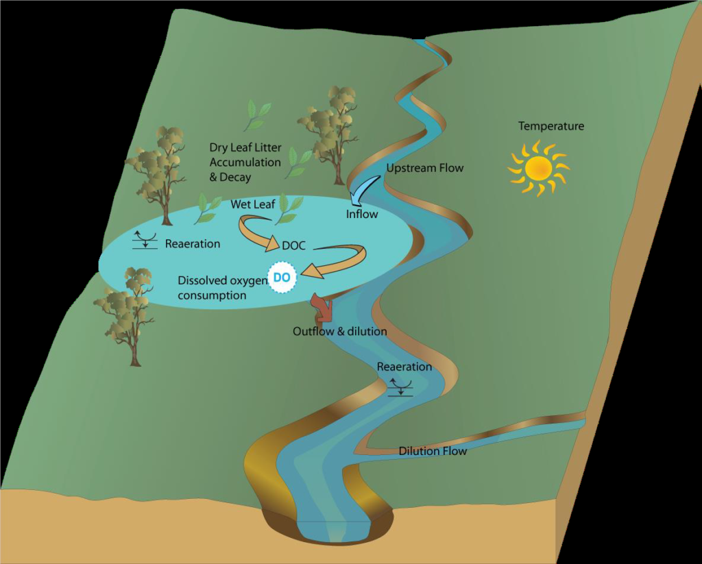
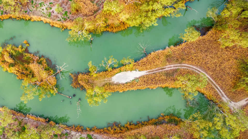
While inundation brings a range of ecological benefits, it also has the potential to cause hypoxic blackwater (low dissolved oxygen) events. Blackwater events occur when inundation washes organic material from the floodplains into waterways leading to a rise in dissolved organic carbon in the water. This causes the water to turn a dark colour. The increased bacterial activity breaking down the carbon consumes oxygen, which causes a drop in levels of dissolved oxygen. In some circumstances, levels can drop so much that fish and other aquatic organisms do not have enough oxygen and die.

Blackwater can also create challenges for downstream water use, such as increasing treatment costs for drinking water supplies.

Blackwater events are a natural feature of many river systems. However, when natural flood patterns are changed and there are longer periods between overbank flows, the amount of organic material can be substantially increased, exacerbating the risk.

Changes to the natural inundation patterns of floodplains can increase the risk of blackwater events.

The project

As part of the South Australian Riverland Floodplain Integrated Infrastructure Program (SARFIIP), the South Australian and Commonwealth governments have invested in major infrastructure upgrades to provide water to the Pike and Katarapko floodplains. The infrastructure allows the Department for the Environment and Water (DEW) to create higher water levels to inundate the wetlands, improving watering frequency and the ecological health of the floodplains.The project includes a number of initiatives to manage potential blackwater risks. This has included developing a model to help understand and predict dissolved oxygen responses to different inundation events, giving DEW important information to design watering events with reduced risk of blackwater events occurring.

Spreadsheet models were previously used to help understand blackwater risks (Howitt et al. 2007, Whitworth and Baldwin 2016, known as the Blackwater Risk Assessment Tool – BRAT). While effective for non-complex situations, DEW was unable to represent realistic hydrology, such as events where water flowed into and out of different floodplains along the river. A more sophisticated approach was required. DEW determined the best approach to be to develop a Source plugin to model blackwater processes on the floodplains.

DEW and the Murray-Darling Basin Authority use the Source modelling framework to help manage the River Murray System. The Source framework uses “plugins” as a flexible way to build additional modelling capability into model. Combined with the South Australian Source Murray Model, the new Blackwater plugin allows DEW to model interactions between the river and floodplains and the different processes that contribute to the risk of blackwater events.

The approach

Conceptually, the model is based on the original spreadsheet models and represents the key influences on the generation of blackwater events (from SMEC 2015):

  • time period since the last inundation
  • the duration and rate of inundation
  • water exchange during inundation
  • temperature
  • area of inundation
  • litter loading
  • depth of inundation
  • influence of floodplain creeks on dilution
  • river dilution flows and proximity to environmental values

In addition, the model includes location specific information such as elevation, floodplain area and litter accumulation (from vegetation type), to understand the extent of inundation and litter accumulation.

The blackwater plugin is set up to represent all of the River Murray in South Australia, to consider interactions between the river and floodplains, as well as cumulative effects from multiple operations being inundated at the same time.

Conceptual model of the processes represented in the Source Blackwater plugin

Model performance

Model performance was tested in two ways. Firstly, simple floodplain scenarios were run through the Blackwater Risk Assessment Tool (BRAT) and the plugin. The results were comparable.

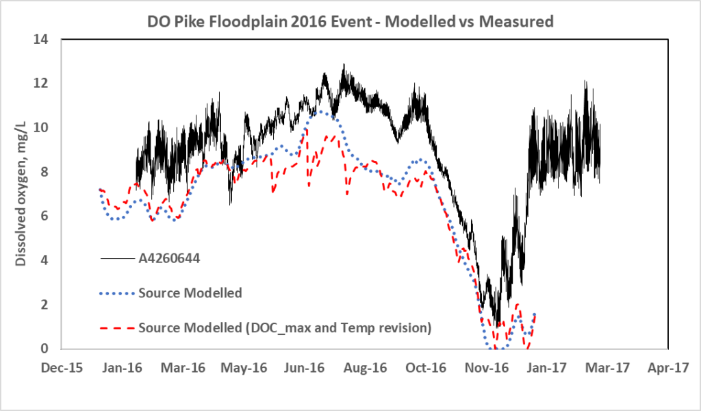
Secondly, a natural high flow event that inundated the Pike Floodplain in late 2016/early 2017 provided an opportunity to compare the model performance against observed DO data. The model compared well with the measured DO trends and magnitude but further testing under a wider range of scenarios is required to fully test the model. Notably, the event shows the importance of interactions with the river during blackwater events, as the majority of the DO decrease on the floodplain during Oct-Nov 2016 appears to relate to the low DO in the inflow water.

Modelled versus measured (at station A4260644, Pike River at Lettons downstream Rumpagunya Creek) dissolved Oxygen levels during the 2016-17 inundation event
Modelled versus measures (Station A42602644, Pike River at Lettons downstream Rumpagunyah Creek) Dissolved Oxygen levels on the Pike Floodplain during the 2016-17 inundation event.

Implementation

The model supports DEW to:

  • understand the potential DO changes associated with different environmental watering actions on the floodplains
  • adjust proposed watering actions to reduce the risk of blackwater events
  • forecast potential DO changes and blackwater risks from floods, and to identify potential river operations to minimise forecast blackwater events.

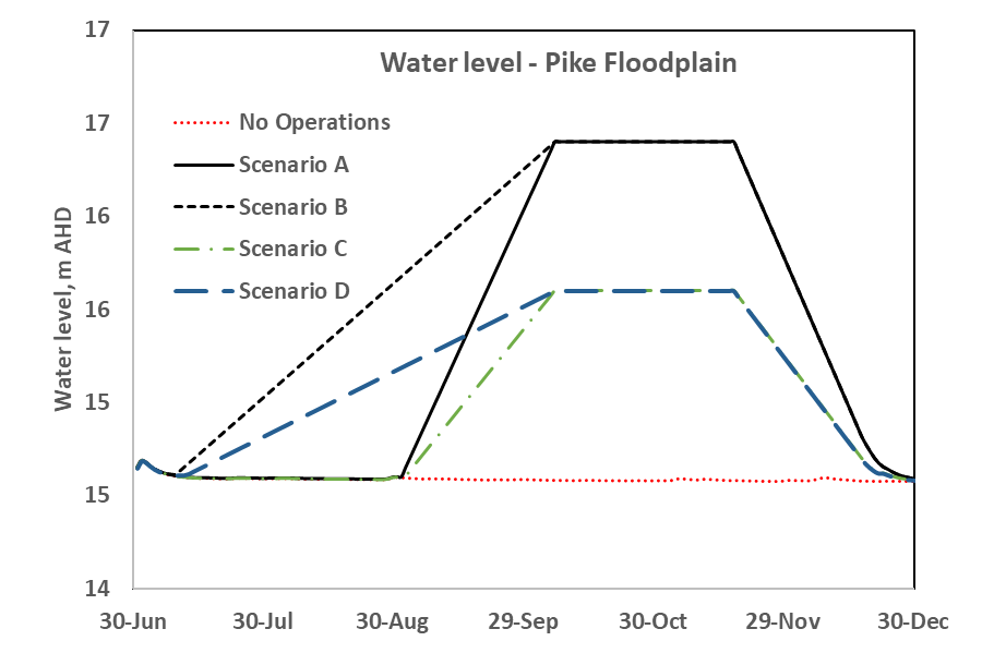
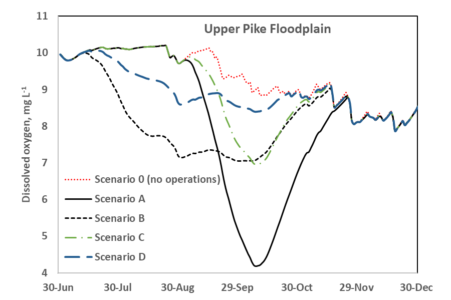
The figures below are two examples of the blackwater plugins outputs. The first shows the range of floodplain inundation under five different scenarios. The second shows forecast dissolved oxygen levels for each of the scenarios.

Hypothetical scenarios of water level upstream of environmental regulators to create floodplain inundation

Scenario A represents a fast fill of the floodplain to full inundation extent, potentially resulting in DO concentrations that could be detrimental to aquatic biota. Through the use of the DODOC plugin, operations can be designed to reduce these impacts.

Project partners

This work forms part of the $155 million South Australian Riverland Floodplains Integrated Infrastructure Program (SARFIIP) to improve the health and resilience of Riverland floodplains. SARFIIP is funded by the Australian Government through the Murray–Darling Basin Authority and implemented by DEW in partnership with SA Water.

The Blackwater Plugin was developed for DEW by the University of Adelaide and Flow Matters Pty Ltd. eWater was engaged by DEW to further develop functionality and modify the plugin to better work with improvements made to the Source platform after the plugin was developed.

References

Howitt JA, Baldwin DS, Rees GN and Williams JL (2007). Modelling blackwater: predicting water quality during flooding of lowland river forests. Ecological Modelling 203 (3–4):229–242. doi:10.1016/j.ecolmodel.20

SMEC (2015). SARFIIP Blackwater Risk Assessment: Stage 1. Report to the Department of Environment, Water and Natural Resources. SMEC, Adelaide in association with Natural Logic (Karla Billington) and University of Adelaide (Luke Mosley)

Whitworth KL, Baldwin DS (2016). Improving our capacity to manage hypoxic blackwater in lowland rivers: the Blackwater Risk Assessment Tool. Ecological Modelling 320, 292–298. 06.11.017

Acknowledgements

This case study was prepared in collaboration with the SA Department for Environment and Water and Murray-Darling Basin Authority.