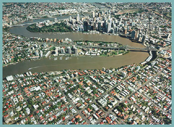
Brisbane River
Coordinator: Tony Weber, WBM
Oceanics
 The
Catchment at a Glance The
Catchment at a Glance
The Brisbane River Catchment has a sub-tropical
climate, with 1.5m of rainfall a year, mostly
as intense summer storms. The catchment area is
13,500km2 in size and extends from Moreton Bay
to the Great Dividing Range. This catchment includes
the sub-catchments of the Upper Brisbane, Stanley,
Lockyer and Bremer Rivers. It includes 850kms
of river and lake banks as well as 50 major creeks.
The Brisbane River is the largest river in the
Catchment. Eighty kms of the river’s lower
reaches are tidal and flood prone with 11 ‘major
floods’ recorded in Brisbane since 1840.
Only 14% of the catchment is currently uncleared.
Land use is varied, including significant areas
of urban, grazing, cropping and forested lands.
The upper catchment is mainly rural, while the
lower catchment is urbanised. The Brisbane River
Catchment supports the largest population of any
catchment in Queensland (in excess of one million),
and being part of SE Queensland, is currently
experiencing rapid population growth. For example,
from 1991 to 2031 it has been estimated that there
will be a 78% increase in the population of Brisbane
City. As a consequence of this population, there
are 40 sewage treatment plants (STPs) in the catchment.
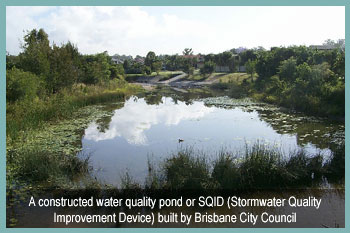
In Brisbane City alone, there are over 2,100km
of enclosed urban stormwater drains and 8,200km
of ‘kerb and channel’ stormwater drainage.
The Brisbane River Catchment drains to Moreton
Bay (1,523km2 in area), a shallow bay sheltered
from the Pacific Ocean by the islands of Moreton
and North Stradbroke to the east. The Bay plays
a major role in the economy of the region and
the lifestyle of its people. Brisbane in the only
place in the world where 700-900 dugong graze
on seagrasses within sight of a major City. The
Bay also hosts internationally recognised sites
for migratory birds and supports a significant
fishing industry. The Bay’s recreational
fishing industry alone is worth over $400M p.a.
Key Waterway-Related Issues
The following issues are nominated by the Author
as currently being the most significant waterway-related
issues facing the catchment (in no particular
order):
- Flooding (regional and local).
- Sediment loads/turbidity in creeks, the river
and bay (from urban stormwater and rural land
uses).
- Nutrient loads in creeks, the River and Bay
(e.g. algal blooms in the Western Bay are principally
linked to nitrogen discharges from STPs).
- Weeds (aquatic and riparian).
- Degradation and discontinuity of riparian
vegetation.
- High concentrations of nutrients, bacteria
and phytoplankton in creeks within the upper
catchment.
- Sewer overflows and urban stormwater impacting
upon urban creeks.
- Water supply and environmental flows.
- Litter and toxicants (e.g. pesticides and
heavy metals) in creeks, the River and Bay.
- Bank erosion (particularly creeks in the upper
catchment).
Largely because of the widely recognised work
of the SE Qld Regional Water Quality Management
Strategy (SEQRWQMS or ‘The Moreton Bay Study’),
catchment managers now have a good understanding
of cause-effect relationships in tidal waterways,
and are implementing suitable actions. However,
scientific investigations are still in their infancy
in freshwater areas via the SEQRWQMS (with help
from CRCs and others). There is still much to
learn about the health of these systems, the key
threats, sources of pollutants and importantly,
necessary management actions.
Key Stakeholders Involved
with Catchment Management and Research
Local stakeholder groups that are actively
involved in catchment management and research
include:
- Local governments and their various reference
groups.
- Numerous community/catchment groups (e.g.
in Brisbane City Council alone there are currently
16 formally recognised catchment groups).
- Commonwealth Government (e.g. through NHT
funded projects).
- State Government (e.g. the Environmental Protection
Agency, Department of Natural Resources and
Mines, Department of Primary Industries, Queensland
Transport).
- Port of Brisbane Corporation.
- SEQ Water Board.
- CRCs (i.e. Catchment Hydrology, Coastal Zones,
Freshwater Ecology).
- Local universities (University of Qld, Griffith,
Qld University of Technology).
- Industry associations (SIA, IEAust, HIA, QMBA,
UDIA, etc.) and local groups such as the Urban
Stormwater Information Group which represents
key urban stormwater managers from across SE
Qld.
- The SEQRWQMS (the Strategy will continue until
2001).
Want More Information?
The Crew Member's Guide to the Health of
Our Waterways (SEQRWQMS, 1998) is an excellent
layperson's summary of the SEQRWQMS's scientific
findings involving the lower catchment (contact
the SEQRWQMS on 07 3403 4206).
The Moreton Bay Study - A Scientific Basis
for the Healthy Waterways Campaign (SEQRWQMS,
1999) is a companion document to the above, but
aimed at the scientific community (contact the
SEQRWQMS on 07 3403 4206).
The Moreton Bay Catchment Water Quality Management
Strategy (SEQRWQMS, 1998) summarises those
actions being taken by stakeholders in the region
to address the findings of the SEQRWQMS for tidal
waters (contact the SEQRWQMS on 07 3403 4206).
This Strategy is being updated as scientific investigations
now involve the Catchment's freshwater areas.
The Urban Stormwater Management Strategy
(BCC, 1999) summarises those actions being taken
by Brisbane City Council to manage urban waterways
within its jurisdiction (contact Council on 07
3403 9402).
Tony Weber
Focus Catchment Coordinator (Brisbane River Catchment)
trweber@wbmpl.com.au |